IMAGES TAKEN NEAR TO
High Lands, BISHOP AUCKLAND, DL13 5AT
Introduction
This page details the photographs taken nearby to High Lands, DL13 5AT by members of the Geograph project.
The Geograph project started in 2005 with the aim of publishing, organising and preserving representative images for every square kilometre of Great Britain, Ireland and the Isle of Man.

There are currently over 7.5m images from over14,400 individuals and you can help contribute to the project by visiting https://www.geograph.org.uk
Image Map
Images are licensed for reuse under creativecommons.org/licenses/by-sa/2.0
Notes
- Clicking on the map will re-center to the selected point.
- The higher the marker number, the further away the image location is from the centre of the postcode.
Image Listing (12 Images Found)
Images are licensed for reuse under creativecommons.org/licenses/by-sa/2.0
Image
Details
Distance
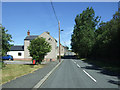
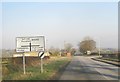
1
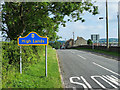
Minor road entering High Lands from the north
High Lands is a small settlement in County Durham, along this same road as Low Lands; both are close to the larger villages of Cockfield and Butterknowle. The blue and yellow road sign is in the style used now in County Durham to announce reaching a settlement. At the time the image was recorded a local resident told the photographer that the community had made a specific request to the county council that up-to-date signs be erected due to deterioration of their existing ones.
Image: © Trevor Littlewood
Taken: 14 Jun 2020
0.02 miles
2
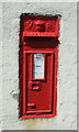
Victorian postbox, High Lands
Postbox No. DL13 56.
See Image] for context.
Image: © JThomas
Taken: 25 Jun 2018
0.02 miles
3
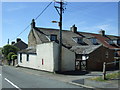
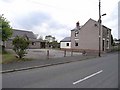
Houses, High Lands
Showing position of Postbox No. DL13 56.
See Image] for postbox.
Image: © JThomas
Taken: 25 Jun 2018
0.03 miles
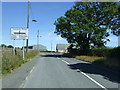
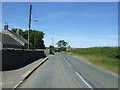
5
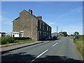
Lands Road (B6282) approaching crossroads
Image: © Peter Robinson
Taken: 17 Feb 2013
0.08 miles
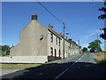
8
House on Landsbank, High Lands
This house - formerly one of a terrace, but part of the terrace to the north has been demolished - was owned by my son in the 1990s. The house now bears the sign "Rabymar Cavaliers" - the present owners breed dogs. The building to the left is Lands Village Hall.
Image: © Oliver Dixon
Taken: 2 Jun 2009
0.16 miles