IMAGES TAKEN NEAR TO
Leazes Lane, BISHOP AUCKLAND, DL13 3DS
Introduction
This page details the photographs taken nearby to Leazes Lane, DL13 3DS by members of the Geograph project.
The Geograph project started in 2005 with the aim of publishing, organising and preserving representative images for every square kilometre of Great Britain, Ireland and the Isle of Man.

There are currently over 7.5m images from over14,400 individuals and you can help contribute to the project by visiting https://www.geograph.org.uk
Image Map
Images are licensed for reuse under creativecommons.org/licenses/by-sa/2.0
Notes
- Clicking on the map will re-center to the selected point.
- The higher the marker number, the further away the image location is from the centre of the postcode.
Image Listing (10 Images Found)
Images are licensed for reuse under creativecommons.org/licenses/by-sa/2.0
Image
Details
Distance
1
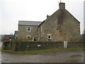
Leazes Farmhouse Wolsingham
In Weardale County Durham seen from the Public Footpath on the farm access road
Image: © Peter Robinson
Taken: 7 Feb 2010
0.02 miles
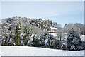
3
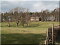
Field north of Ladley Burn and south of Ladley Burn
A field, south of Ladley Burn the house - seen against the backdrop of trees and north of Ladley Burn the stream - out of view in front of the camera position; the footpath runs along its north bank.
Image: © Trevor Littlewood
Taken: 24 Mar 2011
0.15 miles
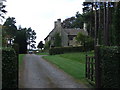
4
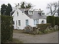
Overdale Wolsingham County Durham
A private residence on Leazes Lane north west of the town
Image: © Peter Robinson
Taken: 7 Feb 2010
0.15 miles
5
Ladley Burn
The large house at Ladley Burn might be thought to have taken its name from a nearby stream but no such named watercourse can be found on OS maps. The stream within the trees beyond the foreground field is Thornhope Beck.
Image: © Trevor Littlewood
Taken: 15 Jan 2021
0.15 miles
7
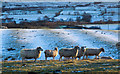
Sheep with lightly snowed fields
The sheep are in a field sloping down to Thornhope Beck near to Wolsingham. The field surface immediately beyond the sheep is thrown into corrugations which are made more apparent by the thinly lying snow. That pattern could be due to an ancient method of ploughing fields in strips, known as 'ridge and furrow'; see https://en.wikipedia.org/wiki/Ridge_and_furrow
Image: © Trevor Littlewood
Taken: 14 Jan 2017
0.16 miles
8
Three crossings of Thornhope Beck - 3
Part of a series of three photographs of crossings over Thornhope Beck. After the footbridge Image and the ford with stepping stones Image the lowest crossing is by road bridge.
Image: © Oliver Dixon
Taken: 25 Jan 2007
0.17 miles
9
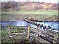
Three crossings of Thornhope Beck - 2
Part of a series of three photographs of crossings over Thornhope Beck. After the footbridge upstream Image the path crosses the stream again via a ford with stepping stones.
Image: © Oliver Dixon
Taken: 25 Jan 2007
0.21 miles
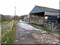
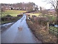
10

Ford and Stepping Stones at Wolsingham
This is the first of three fords leading down from Leazes Farm on Thornhope Beck at Wolsingham.
Image: © John Walton
Taken: 13 Mar 2015
0.23 miles