IMAGES TAKEN NEAR TO
Stanhope, BISHOP AUCKLAND, DL13 2YJ
Introduction
This page details the photographs taken nearby to DL13 2YJ by members of the Geograph project.
The Geograph project started in 2005 with the aim of publishing, organising and preserving representative images for every square kilometre of Great Britain, Ireland and the Isle of Man.

There are currently over 7.5m images from over14,400 individuals and you can help contribute to the project by visiting https://www.geograph.org.uk
Image Map
Images are licensed for reuse under creativecommons.org/licenses/by-sa/2.0
Notes
- Clicking on the map will re-center to the selected point.
- The higher the marker number, the further away the image location is from the centre of the postcode.
Image Listing (43 Images Found)
Images are licensed for reuse under creativecommons.org/licenses/by-sa/2.0
Image
Details
Distance
1
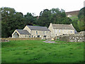
High Shittlehope Burn Farm and Barn
See Image The farm is not particularly "high" - it's only 150 metres or so from the main road through Weardale (the A689) and only slightly above it - and was probably so named only to distinguish it from Shittlehope Burn Farm on the south side of the road. Christine Ruskin gives the name as simply "Shittlehope", as does the 1:25,000 map. She gives an earliest record of occupation of 1381, followed by the names of two occupants in the mid-17th C, then the 1901 census. The buildings were semi-derelict when photographs were taken for the 1st edition of the book, but in the second, a photo of the renovations is dated 2015.
Image, which is some 75 metres higher up, can be seen through the gap in the trees on the right.
Image: © Mike Quinn
Taken: 18 Sep 2020
0.01 miles
3
Sunken path near Shittlehopeside Farm (3)
Image: © Mike Quinn
Taken: 18 Sep 2020
0.07 miles
5
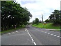
Main road coming into Stanhope from the east
Looking west along the A689, the main road along Weardale. This is at the east end of the village.
Image: © Robert Graham
Taken: 23 Jul 2024
0.09 miles
6
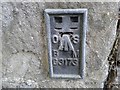
Ordnance Survey Flush Bracket G3173
This can be found on the wall of a building at Low Shittlehope.
For more detail see : http://www.bench-marks.org.uk/bm685
Image: © Peter Wood
Taken: 23 Aug 2014
0.09 miles
7
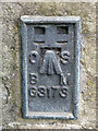
OSBM flush bracket on a building near Shittlehope Burn Bridge
Image: © Mike Quinn
Taken: 18 Sep 2020
0.09 miles
8
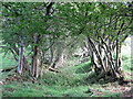
Sunken path near Shittlehopeside Farm (4)
Image: © Mike Quinn
Taken: 18 Sep 2020
0.09 miles
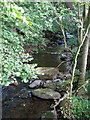
9
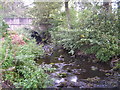
Shittlehope Burn at Stanhope
Image: © GRAEME and LESLEY CRANSTON
Taken: 1 Oct 2006
0.09 miles
10
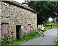
Unusual mode of transport
A tricycle rider passing the old byre at Shittlehope Burn Farm on the outskirts of Stanhope. This minor road comes along the south side of the River Wear from Frosterley and joins the main A689 road just ahead here.
Image: © Robert Graham
Taken: 23 Jul 2024
0.10 miles