IMAGES TAKEN NEAR TO
Frosterley, BISHOP AUCKLAND, DL13 2TE
Introduction
This page details the photographs taken nearby to DL13 2TE by members of the Geograph project.
The Geograph project started in 2005 with the aim of publishing, organising and preserving representative images for every square kilometre of Great Britain, Ireland and the Isle of Man.

There are currently over 7.5m images from over14,400 individuals and you can help contribute to the project by visiting https://www.geograph.org.uk
Image Map
Images are licensed for reuse under creativecommons.org/licenses/by-sa/2.0
Notes
- Clicking on the map will re-center to the selected point.
- The higher the marker number, the further away the image location is from the centre of the postcode.
Image Listing (27 Images Found)
Images are licensed for reuse under creativecommons.org/licenses/by-sa/2.0
Image
Details
Distance
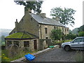
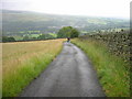
5
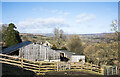
Farm buildings north of Hill End
The buildings are at, or close to Dryburn Side but that name appears to refer to another property a bit lower on the slope, hidden by these.
Beyond the buildings and nearby trees, Weardale extends to the west.
Image: © Trevor Littlewood
Taken: 15 Feb 2022
0.07 miles
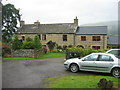
6
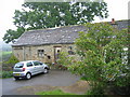
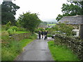
The pretty little hamlet of Dryburn Side
Image: © Roger Smith
Taken: 6 May 2007
0.08 miles
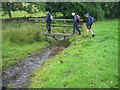
8
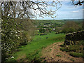
Footpath above Weardale
Frosterley down in the dale.
Image: © Karl and Ali
Taken: 23 May 2017
0.17 miles