IMAGES TAKEN NEAR TO
Rookhope, BISHOP AUCKLAND, DL13 2DF
Introduction
This page details the photographs taken nearby to DL13 2DF by members of the Geograph project.
The Geograph project started in 2005 with the aim of publishing, organising and preserving representative images for every square kilometre of Great Britain, Ireland and the Isle of Man.

There are currently over 7.5m images from over14,400 individuals and you can help contribute to the project by visiting https://www.geograph.org.uk
Image Map (Loading...)


Getting Data...Please wait
Leaflet Map data © OpenStreetMap
Images are licensed for reuse under creativecommons.org/licenses/by-sa/2.0
Notes
- Clicking on the map will re-center to the selected point.
- The higher the marker number, the further away the image location is from the centre of the postcode.
Image Listing (12 Images Found)
Images are licensed for reuse under creativecommons.org/licenses/by-sa/2.0
Image
Details
Distance
1
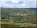
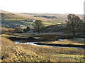
Rook Hope
View looking over Rook Hope to Lintzgarth with Windy Hill in the background.
Image: © Peter McDermott
Taken: 26 Aug 2007
0.10 miles
2
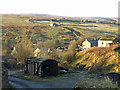
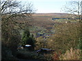
Rookhope
Looking WSW across the valley towards Prydale House. Shows the locations of the Image (foreground) and the Image (right, on the far side of the cleugh of Bolt's Burn).
Image: © Mike Quinn
Taken: 29 Nov 2019
0.10 miles
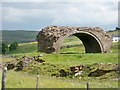
3
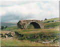
Smelt Mill Flue Arch
This is all that remains of what must have been an enormous structure. This carried an enclosed flue on the top which ran from the smelt mill to the chimney.
Image: © Malcolm Street
Taken: Unknown
0.16 miles
4
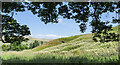
Meadowsweet flowering in Rook Hope
Deep vegetation beside the path on the south side of Rookhope Burn with the creamy flower heads of meadowsweet dominating an area to the right, below the tree boughs.
Image: © Trevor Littlewood
Taken: 16 Jul 2022
0.17 miles
5
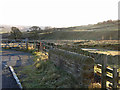
Rookhope Burn at Lintzgarth
Looking east from near the Image past Rookhope towards the Image (photographed by Trevor Littlewood).
Image: © Mike Quinn
Taken: 29 Nov 2019
0.18 miles
6
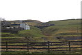
The valley of Rookhope Burn
Looking across the valley from near the bottom of the Boltslaw Incline; on the horizon (just to the right of centre) is the Image Shows the location of Image
Image: © Mike Quinn
Taken: 9 Nov 2009
0.19 miles
7
The Rookhope valley at Lintzgarth (2)
Shows the location of Image
Image: © Mike Quinn
Taken: 29 Nov 2019
0.19 miles
10
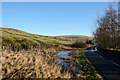
Flood beside road in Rook Hope
Rook Hope is a major tributary valley to Weardale. The view is towards Rookhope, the only village in the valley and the moorland hill in the distance is Long Law.
Image: © Trevor Littlewood
Taken: 9 Jan 2014
0.24 miles