IMAGES TAKEN NEAR TO
West Haswicks, BISHOP AUCKLAND, DL13 1SF
Introduction
This page details the photographs taken nearby to West Haswicks, DL13 1SF by members of the Geograph project.
The Geograph project started in 2005 with the aim of publishing, organising and preserving representative images for every square kilometre of Great Britain, Ireland and the Isle of Man.

There are currently over 7.5m images from over14,400 individuals and you can help contribute to the project by visiting https://www.geograph.org.uk
Image Map
Images are licensed for reuse under creativecommons.org/licenses/by-sa/2.0
Notes
- Clicking on the map will re-center to the selected point.
- The higher the marker number, the further away the image location is from the centre of the postcode.
Image Listing (150 Images Found)
Images are licensed for reuse under creativecommons.org/licenses/by-sa/2.0
Image
Details
Distance
1
Fields near Westgate
Westgate is quite an isolated village near Weardale.
Image: © Malcolm Neal
Taken: 19 Oct 2017
0.03 miles
2
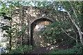
Former Weardale Railway
The blocked up arch of this bridge. The road bridge being altered for the railway. Westgate station was the other side of this bridge.
http://www.disused-stations.org.uk/w/westgate/index.shtml
Image: © Ashley Dace
Taken: 27 Jul 2011
0.04 miles
3
Bridge over the former Weardale railway
See Image
Image: © Mike Quinn
Taken: 12 May 2019
0.04 miles
4
Westgate Station
The former station.
http://www.disused-stations.org.uk/w/westgate/index.shtml
Image: © Ashley Dace
Taken: 27 Jul 2011
0.04 miles
5
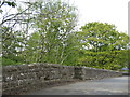
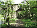
Haswick's Bridge
There are actually two bridges here: the original (further one) with a flat parapet (Haswick's) over the River Wear - see Image and Image - and the later (nearer) bridge with a slight peak in its parapet, over the former Weardale railway - see Image
Image: © Mike Quinn
Taken: 12 May 2019
0.04 miles
6
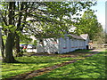
The (former) Westgate Station building
Now a community centre.
Image: © Mike Quinn
Taken: 2 May 2009
0.04 miles
7
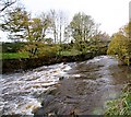
Rapid below Westgate bridge
In any but the very highest flows, the River Wear is paddled through the right arch of Westgate bridge, and the current then sets against the right hand bank, so paddlers need to ferry back into the middle of the river to take this little drop somewhere in the centre. After this, the river relaxes a little, with nothing more than shingle rapids for some distance.
Image: © Andy Waddington
Taken: 8 Nov 2009
0.05 miles
8
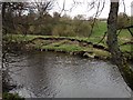
Erosion of the river bank - Westgate
Erosion of the river bank on the Westgate side of the River Wear. (Taken from the Haswicks side)
Image: © Ayre
Taken: 18 Apr 2015
0.05 miles
9
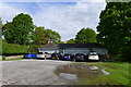
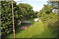
Free car park, Westgate
On the site of Westgate's former railway station (opened 1895, closed 1968 http://disused-stations.org.uk/w/westgate/index.shtml )
Image: © Tim Heaton
Taken: 17 May 2022
0.05 miles
10
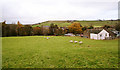
Haswicks field
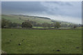
A stile with disconcertingly wobbly precast concrete steps leads from the south of the Westgate bridge into this field, from where footpaths diverge, one to follow the river right bank upstream, the other to cross the field up the hill. This view looks back on the latter from near the top of the field towards Westgate village. The buildings on the right are West Haswicks, a small group of houses, which, along with a similar sized group up the lane, East Haswicks, make up the hamlet of Haswicks on the south side of the River Wear.
Image: © Andy Waddington
Taken: 8 Nov 2009
0.05 miles