IMAGES TAKEN NEAR TO
Lanehead, BISHOP AUCKLAND, DL13 1AT
Introduction
This page details the photographs taken nearby to DL13 1AT by members of the Geograph project.
The Geograph project started in 2005 with the aim of publishing, organising and preserving representative images for every square kilometre of Great Britain, Ireland and the Isle of Man.

There are currently over 7.5m images from over14,400 individuals and you can help contribute to the project by visiting https://www.geograph.org.uk
Image Map
Images are licensed for reuse under creativecommons.org/licenses/by-sa/2.0
Notes
- Clicking on the map will re-center to the selected point.
- The higher the marker number, the further away the image location is from the centre of the postcode.
Image Listing (21 Images Found)
Images are licensed for reuse under creativecommons.org/licenses/by-sa/2.0
Image
Details
Distance
1
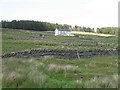
White Hall
Remote dwelling as seen from the A689, beside the upper reaches of the Killhope Burn
Image: © Chris Heaton
Taken: 17 May 2022
0.00 miles
2
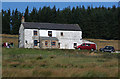
White Hall
The house at White Hall near the head of Killhope Burn.
Image: © Peter McDermott
Taken: 26 Sep 2009
0.02 miles
3
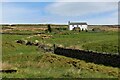
White Hall
One of the higher houses in Weardale, and at 530m this must be amongst the highest inhabited places in Britain.
Image: © Richard Webb
Taken: 1 Jul 2008
0.02 miles
4
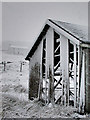
Snowy barn
Abandoned barn in the snow with farmhouse behind
Image: © Helen Wilkinson
Taken: Unknown
0.11 miles
6
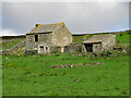
Row
See Image In the 2nd edition of her book, Christine Ruskin reproduces the record from the 1911 census that shows that 9 people lived in this small house. Life then would have been very hard: the house is nearly 530 metres (around 1,730 ft) above sea level on a steeply-sloping and exposed hillside with no trees to form a wind break, less than 2 km (1 mile) below the head of the pass into Cumbria that carries the highest A road in England - and with no "mains" services: no running water, no sewerage, no electricity, no gas and no telephone.
Even so, there are three houses nearby: Image (photographed by Richard Webb) to the west and Cleugh House to the east, both at about the same height, and Hill Top, another 15 metres directly above Row - see Image There's also one house even further up the valley: Bank Foot, shown in Image (photographed by Helen Wilkinson) which lies at a height of around 550 metres (1,800 ft) above sea level and is (I think) the highest occupied dwelling in the whole of the North Pennines.
Image: © Mike Quinn
Taken: 13 Jul 2023
0.13 miles
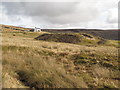
7

A splash of colour...
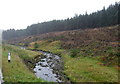
Vivid red lichen mixed with duller green colours, and a single small pine tree, on the south bank of the Killhope Burn beside A689 to western side of village.
Image: © Barry Boxer
Taken: 23 Oct 2009
0.13 miles
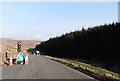
9
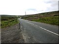
The A689 near to Killhopehead
This photo was taken from a similar position to that of Andrew Smith's in 2006 Image, but it's apparent that the plantation on the right has now been completely cleared.
Image: © David Gearing
Taken: 26 Jul 2011
0.17 miles