IMAGES TAKEN NEAR TO
Baldersdale, BARNARD CASTLE, DL12 9UL
Introduction
This page details the photographs taken nearby to DL12 9UL by members of the Geograph project.
The Geograph project started in 2005 with the aim of publishing, organising and preserving representative images for every square kilometre of Great Britain, Ireland and the Isle of Man.

There are currently over 7.5m images from over14,400 individuals and you can help contribute to the project by visiting https://www.geograph.org.uk
Image Map
Images are licensed for reuse under creativecommons.org/licenses/by-sa/2.0
Notes
- Clicking on the map will re-center to the selected point.
- The higher the marker number, the further away the image location is from the centre of the postcode.
Image Listing (13 Images Found)
Images are licensed for reuse under creativecommons.org/licenses/by-sa/2.0
Image
Details
Distance
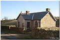
2
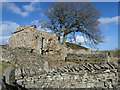
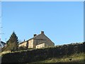
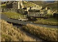
Freewill House, Briscoe
This ruin is one of the earliest Nonconformist chapels in the North Pennines. It had two chapel rooms, a home for the Chapel Keeper, and space to keep sheep in, as well as a garden and three small fields. It was thatched with heather. No-one is sure when it was built, but John Killen and Ann Addison, who married in 1746, raised a family here. The chapel was an important meeting place in the 1700s and 1800s, but was replaced by the Briscoe Free Mission Gospel Chapel in 1905.
Image: © Christine Johnstone
Taken: 29 Feb 2020
0.07 miles
3
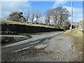
Road junction at Freewill House
The gravelled verge allows drivers to turn from one narrow lane into the other. The route of the 'main road' [Briscoe Lane] is shown by the double row of trees.
Image: © Christine Johnstone
Taken: 29 Feb 2020
0.07 miles
4
East Briscoe Ford
This ford is found at East Briscoe.
Image: © John Walton
Taken: 18 Mar 2014
0.08 miles
5
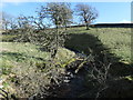
Fallen trees in How Beck
After weeks of wet and stormy weather.
Image: © Christine Johnstone
Taken: 29 Feb 2020
0.08 miles
6
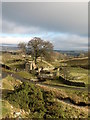
Trees above How Beck
Just downstream from Freewill House, Briscoe.
Image: © Christine Johnstone
Taken: 29 Feb 2020
0.09 miles
7
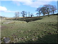
The valley of How Beck
A moorland beck which has carved an attractive little valley on the southern flanks of Baldersdale.
Image: © Gordon Hatton
Taken: 12 Jan 2008
0.11 miles
8
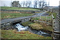
Watersplash & Footbridge
The watersplash (mostly ice today) & footbridge over How Beck, near Briscoe.
Image: © Matthew Hatton
Taken: 12 Jan 2007
0.12 miles
9
The Old Chapel, Baldersdale
Once an old chapel, now converted into a holiday let. Close to the old home of Hannah Hauxwell.
Image: © Alan Rolfe
Taken: 28 Dec 2003
0.16 miles
10
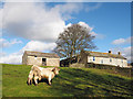
Bull in enclosure at East Briscoe
At larger scales OS mapping names the buildings as being at Briscoe Farm but the name is also applied to another nearby farm.
Image: © Trevor Littlewood
Taken: 3 Nov 2014
0.18 miles