IMAGES TAKEN NEAR TO
Town Pasture Lane, BARNARD CASTLE, DL12 8BF
Introduction
This page details the photographs taken nearby to Town Pasture Lane, DL12 8BF by members of the Geograph project.
The Geograph project started in 2005 with the aim of publishing, organising and preserving representative images for every square kilometre of Great Britain, Ireland and the Isle of Man.

There are currently over 7.5m images from over14,400 individuals and you can help contribute to the project by visiting https://www.geograph.org.uk
Image Map
Images are licensed for reuse under creativecommons.org/licenses/by-sa/2.0
Notes
- Clicking on the map will re-center to the selected point.
- The higher the marker number, the further away the image location is from the centre of the postcode.
Image Listing (8 Images Found)
Images are licensed for reuse under creativecommons.org/licenses/by-sa/2.0
Image
Details
Distance
1
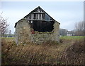
Decrepit barn at Stainton Grove
In a neglected corner of the field stands a sorry looking barn, with a rusting corrugated iron roof. The south wall appears to have had a large door blocked up with stone, but both the upper part of the wall, and the blocking up have collapsed leaving a gaping hole. That must have led to the loss of the original roof, the replacement gable being wooden boards, and the rest of the hole being blocked with more corrugated iron, to all intents and purposes held together with barbed wire.
Image: © Andy Waddington
Taken: 3 Dec 2009
0.01 miles
2
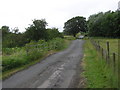
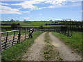
Railway Crossing : Town Pasture Lane
The north end of the lane with Stainton Grove far right. (Darlington and Barnard Castle Branch Line)
Image: © Hugh Mortimer
Taken: 9 Jul 2006
0.07 miles
4
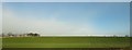
Railway Trackbed
Looking west toward Barnard Castle on Town Pasture Lane.
Image: © Hugh Mortimer
Taken: 9 Jul 2006
0.09 miles
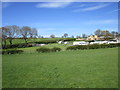
5
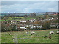
Stainton Grove
This view from Town Pasture Lane, known locally as Gypsy Lane, shows The Oval which was built on the site of Blackbeck PoW Camp.
Image: © Eileen O'Hara
Taken: 13 Nov 2007
0.09 miles
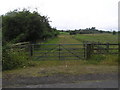
6
Entrance to a sewage works off Town Pasture Lane
Image: © Jonathan Thacker
Taken: 4 May 2018
0.11 miles
8
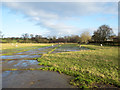
Concreted areas in field
The concreted areas are in a field on the north side of the A688 at Stainton Grove; they form a symmetrical pattern and are indicated on OS maps from the 1:25 000 scale upwards. Their purpose is unknown.
Image: © Trevor Littlewood
Taken: 29 Dec 2015
0.22 miles