IMAGES TAKEN NEAR TO
Barningham, RICHMOND, DL11 7EA
Introduction
This page details the photographs taken nearby to DL11 7EA by members of the Geograph project.
The Geograph project started in 2005 with the aim of publishing, organising and preserving representative images for every square kilometre of Great Britain, Ireland and the Isle of Man.

There are currently over 7.5m images from over14,400 individuals and you can help contribute to the project by visiting https://www.geograph.org.uk
Image Map
Images are licensed for reuse under creativecommons.org/licenses/by-sa/2.0
Notes
- Clicking on the map will re-center to the selected point.
- The higher the marker number, the further away the image location is from the centre of the postcode.
Image Listing (7 Images Found)
Images are licensed for reuse under creativecommons.org/licenses/by-sa/2.0
Image
Details
Distance
1
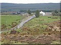
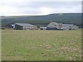
Stang Foot
A farm much given over to horses at the foot of Stang Forest. The Stang is a formidable hill between the Greta Valley and Arkengarthdale. Stang is apparently a word taken from the Norse meaning a pole or a stake. Compare with Yorkshire dialect biggerstang (a builders' scaffold pole) and the Yorkshire folk custom of 'Riding the Stang' where a person to be upheld for public ridicule (especially for wife-beating) was placed astride a pole and carried around to the accompaniment of whistles and jeers. http://www.viking.no/e/england/e-viking_words_2.htm (Not sure this is entirely relevant, but is interesting in its own right).
Image: © Oliver Dixon
Taken: 13 Mar 2007
0.02 miles
2
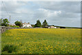
Farm and field at Stang Foot
Stang Foot is a farm beside the minor road crossing from the A66 to Arkengarthdale.
Image: © Trevor Littlewood
Taken: 29 Jun 2013
0.04 miles
5
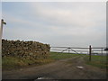
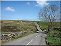
Footpath to Garnthwaite farm and beyond
Image: © Peter Robinson
Taken: 15 Jan 2012
0.17 miles
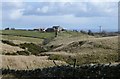
7
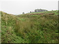
West Hope
A farm on a side road off the Stang road. Stang Forest lies beyond. The patch which is almost bare of trees near the top is Hope Edge Image
Image: © Oliver Dixon
Taken: 13 Mar 2007
0.25 miles