IMAGES TAKEN NEAR TO
Hudswell, RICHMOND, DL11 6BP
Introduction
This page details the photographs taken nearby to DL11 6BP by members of the Geograph project.
The Geograph project started in 2005 with the aim of publishing, organising and preserving representative images for every square kilometre of Great Britain, Ireland and the Isle of Man.

There are currently over 7.5m images from over14,400 individuals and you can help contribute to the project by visiting https://www.geograph.org.uk
Image Map
Images are licensed for reuse under creativecommons.org/licenses/by-sa/2.0
Notes
- Clicking on the map will re-center to the selected point.
- The higher the marker number, the further away the image location is from the centre of the postcode.
Image Listing (7 Images Found)
Images are licensed for reuse under creativecommons.org/licenses/by-sa/2.0
Image
Details
Distance
1
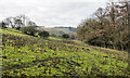
Field with massed thistle stalks
The thistle stems are the dead remnants of the previous summer's flowering of, probably, creeping thistle. New plants will grow during the coming growing season. The trees to the right are in Kirkgate Wood.
Image: © Trevor Littlewood
Taken: 15 Jan 2022
0.12 miles
2
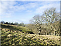
Trees above Kirkgate Wood
The nearer trees are either in the wood or just outside it. The location is just to the west of Scarcote Gill along a path through the northern side of MOD land.
Image: © Trevor Littlewood
Taken: 15 Jan 2022
0.18 miles
3
Path to Thorpe under Stones
One would imagine that this path sees little use as it has long been a route which doesn't easily link with others. However it does now cross a permissive path linking the Husdwell area with Downholme along the rim of the dale.
Image: © Gordon Hatton
Taken: 29 Jul 2015
0.21 miles
4
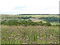
Thistles are what Eeyore likes best
A very thistly field close by the Hudswell to Downholme road. In the distance, across the dale is the limestone scar by Willance's leap and the masts by the Richmond to Marske old road.
Image: © Gordon Hatton
Taken: 29 Jul 2015
0.22 miles
5
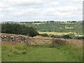
Gate on path leading into the Swale valley
One of those field gates where you have to heave it upwards to release the catch. The path leads downhill past the house at Thorpe under Stone to reach the A6108, but there's no path leading onwards from there, and the main road wouldn't be a pleasant one to walk along. Not surprising that this path is little used.
Image: © Gordon Hatton
Taken: 3 Aug 2024
0.22 miles
6
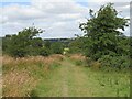
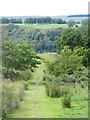
Path towards Thorpe under Stone
The signage at the start of this path might seem a little intimidating with warnings about this being a military training area, but one is unlikely to come across soldiers lurking in the undergrowth or UXB's on the path, which is little used as it doesn't lead anywhere useful.
Image: © Gordon Hatton
Taken: 3 Aug 2024
0.22 miles
7
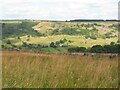
View across the lower end of Swaledale
Taken from a little used footpath on the south side of the valley. This contrasts with one of the most heavily used paths in the country on the far side, where the Coast to Coast route runs.
Unseen, a short way below the camera position is a permissive path which links public rights of way at Hudswell with the small village of Downholme across MOD land. I recall walking this path when it first opened, which must be at least 20 years ago. It crosses the public right of way at the corner of a wood and can be followed gradually ascending the hillside just above the wood.
Image: © Gordon Hatton
Taken: 3 Aug 2024
0.22 miles