IMAGES TAKEN NEAR TO
Whitefields Walk, RICHMOND, DL10 7DE
Introduction
This page details the photographs taken nearby to Whitefields Walk, DL10 7DE by members of the Geograph project.
The Geograph project started in 2005 with the aim of publishing, organising and preserving representative images for every square kilometre of Great Britain, Ireland and the Isle of Man.

There are currently over 7.5m images from over14,400 individuals and you can help contribute to the project by visiting https://www.geograph.org.uk
Image Map
Images are licensed for reuse under creativecommons.org/licenses/by-sa/2.0
Notes
- Clicking on the map will re-center to the selected point.
- The higher the marker number, the further away the image location is from the centre of the postcode.
Image Listing (11 Images Found)
Images are licensed for reuse under creativecommons.org/licenses/by-sa/2.0
Image
Details
Distance
2
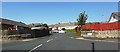
Cross Lanes and Cross Lanes Store
Cross Lanes is an ancient track running from St Nicholas on the Brompton road to Pilmoor Hill on the Gilling West road. Until the early sixties it lay in open countryside until residential development was begun by Shepherd Homes. Cross Lanes Store is the only none residence other than schools in the development. Bizarrely there are no public houses at this end of the town.
Image: © Tony Simms
Taken: 30 May 2015
0.13 miles
3
St. Francis Xavier school, Richmond
Locally known merely as "SFX" it is one of a cluster of schools on the east side of Richmond which certainly do produce sound effects...
Image: © Andy Waddington
Taken: 17 Feb 2011
0.14 miles
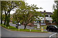
4
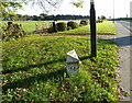
Boundary post, Richmond
The boundary post is beside the A6271.
The most common surviving boundary marks, often taking the form of carved stones, were put up during the 19th century when parish boundaries were re-drawn. Some have the initials of adjacent parishes carved on the appropriate sides. Others consist of metal posts, or old cannon bought from the army and filled with cement; later versions were specially cast in the shape of cannon.
For a wider view of the post Image
Image: © Maigheach-gheal
Taken: 17 Oct 2010
0.18 miles
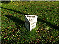
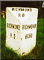
5
Richmond Boundary Stone
On the A6108 Darlington Road approach to Richmond from Scotch Corner.
Image: © David Rogers
Taken: 10 Mar 2009
0.18 miles
6
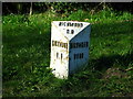
Old Boundary Post by the A6108, Darlington Road, Richmond
HD casting by the A6108, Darlington Road, in parish of Easby (Richmondshire District), Richmond boundary, on verge near sign for Richmond, North side of road.
Inscription reads:-
: RICHMOND / H D : : RICHMOND H D : : RICHMOND / BORO :
Grade II listed.
List Entry Number: 1179632 https://historicengland.org.uk/listing/the-list/list-entry/1179632
Surveyed
Milestone Society National ID: YN_RCDL01
Image: © Milestone Society
Taken: Unknown
0.19 miles
7
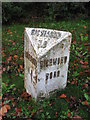
Old Boundary Marker
Municipal Boundary Marker on the north verge of the A6108 Darlington Road, east of its junction with Mile Planting. Closer to the road than YN_RCDL02pb https://www.geograph.org.uk/photo/6472206. On the boundary of Richmond and Easby parishes. In raised lettering RICHMOND / HD (Highway District) and RICHMOND / BORO on adjacent faces and RICHMOND / H.D on its top. This has been moved from the south side of the road where it is shown on old OS maps - Richmond town/borough is to the left of the marker as it stands now. Grade II Listed https://historicengland.org.uk/listing/the-list/list-entry/1179632. See also https://www.geograph.org.uk/photo/2193451 and https://www.geograph.org.uk/photo/1198493.
Milestone Society National ID: YN_RCDL01apb
Image: © Mike Rayner
Taken: 17 Nov 2019
0.19 miles
8
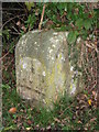
Old Boundary Marker
Parish Boundary Marker on the north verge of A6108 Darlington Road, east of its junction with Mile Planting. Further from the road than YN_RCDL001apb https://www.geograph.org.uk/photo/6472204. On the boundary of Richmond and Easby parishes.
Milestone Society National ID: YN_RCDL02pb
Image: © Mike Rayner
Taken: 17 Nov 2019
0.19 miles
9
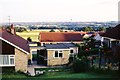
Looking south towards Whitefields Estate and Catterick Garrison, from Ronaldshay Drive, Richmond, North Yorkshire
Ronaldshay Drive had been built in the early 1960's. More houses were then being built on the fields of Whitefields Farm, but in 1971 at the western side only, to the right. The bounds of Richmond were beside the line of trees to the far left. The eastern side of the farm has since been built up, covering most of the green space heading towards the tree line. The field immediately behind this viewpoint has also been developed.
In these days my boss lived in a bungalow, the last house heading out of Richmond on the Darlington Road. The garden seems to have been sold off and more houses have gone in there - that too just within the Richmond bounds.
Catterick Garrison is just visible in the far distance right. That has grown substantially in the last 40 years and is now one of the biggest military bases in Europe. The growth of the army base and the growth of Richmond are not unrelated. Many soldiers buy houses in the area for when they leave the army, and many civilian jobs are created to help service the army personnel and their families.
Image: © Chris Morgan
Taken: Unknown
0.20 miles
10
A6108, Richmond
There is a wide grass verge beside the A6108 with a cast iron boundary post on it.
Image: © Maigheach-gheal
Taken: 17 Oct 2010
0.20 miles