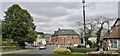
IMAGES TAKEN NEAR TO
Zetland Square, Dundas Street, RICHMOND, DL10 7BP
Introduction
This page details the photographs taken nearby to Zetland Square, Dundas Street, DL10 7BP by members of the Geograph project.
The Geograph project started in 2005 with the aim of publishing, organising and preserving representative images for every square kilometre of Great Britain, Ireland and the Isle of Man.

There are currently over 7.5m images from over14,400 individuals and you can help contribute to the project by visiting https://www.geograph.org.uk
Image Map
Images are licensed for reuse under creativecommons.org/licenses/by-sa/2.0
Notes
- Clicking on the map will re-center to the selected point.
- The higher the marker number, the further away the image location is from the centre of the postcode.
Image Listing (752 Images Found)
Images are licensed for reuse under creativecommons.org/licenses/by-sa/2.0
Image
Details
Distance
1
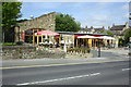
Birra Moretti restaurant, Dundas Street
There is an OS benchmark Image on the restaurant's roadside wall at its junction with the wall of the property on its left, Richmond Community Office, a converted church.
Image: © Roger Templeman
Taken: 5 Jun 2013
0.01 miles
2
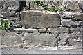
Benchmark on wall on north side of Dundas Street
Ordnance Survey cut mark benchmark described on the Bench Mark Database at http://www.bench-marks.org.uk/bm48904
Image: © Roger Templeman
Taken: 5 Jun 2013
0.02 miles
3
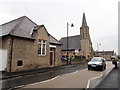
Parish Church Room, Richmond
The former parish church, to the right of the Church Rooms, has been redeveloped as a small business centre.
Image: © Eirian Evans
Taken: 22 Sep 2019
0.02 miles
4
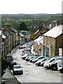
Frenchgate
With the castle in the distance.
Image: © Mick Garratt
Taken: 6 Nov 2005
0.02 miles
5
![Richmond buildings [34]](https://s1.geograph.org.uk/geophotos/07/30/44/7304405_5e66e1d0_120x120.jpg)
Richmond buildings [34]
This mid 18th century house in Queens Road is used as council offices. Constructed of ashlar under a stone slate roof. Listed, grade II, with details at: https://historicengland.org.uk/listing/the-list/list-entry/1260725
Richmond is a picturesque market town in North Yorkshire, some 13 miles northwest of Northallerton and about 11½ miles southwest of Darlington. Set on the north bank of the River Swale, the town is on the edge of the Yorkshire Dales National Park, and is marketed as the Gateway to the Dales. Richmond was founded in 1071 and the castle was completed in 1086. Tourism is important to the local economy, as is the influence of the nearby Catterick Garrison army base. A traditional market operates every Saturday in the large cobbled marketplace.
Image: © Michael Dibb
Taken: 18 Jun 2022
0.03 miles
6
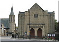
Richmond Methodist Church
Erected more recently than the spired former Congregational Church on Dundas Street which was completed in 1883.
Image: © David Rogers
Taken: 14 Oct 2009
0.03 miles
7
Number 12 Queen's Road
One of the two best buildings on Queen's Road, this modest Georgian house is now council offices.
Image: © Gordon Hatton
Taken: 25 Sep 2008
0.03 miles
8
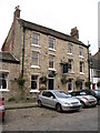
Frenchgate Hotel and Restaurant
Small hotel in a period property on Frenchgate.
Image: © Gordon Hatton
Taken: 25 Sep 2008
0.04 miles
9
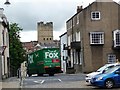
Traffic in Richmond
A lorry negotiating the sharp hillside bend from Dundas Street to Frenchgate.
Image: © Christine Johnstone
Taken: 3 Aug 2010
0.04 miles
10
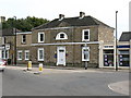
Queens Road, Richmond
The old Post Office is now a pub. The old cinema is now a carpet showroom. The library still survives, but for how much longer?
Image: © Chris Morgan
Taken: 8 Sep 2014
0.04 miles