IMAGES TAKEN NEAR TO
Norman Square, RICHMOND, DL10 4PD
Introduction
This page details the photographs taken nearby to Norman Square, DL10 4PD by members of the Geograph project.
The Geograph project started in 2005 with the aim of publishing, organising and preserving representative images for every square kilometre of Great Britain, Ireland and the Isle of Man.

There are currently over 7.5m images from over14,400 individuals and you can help contribute to the project by visiting https://www.geograph.org.uk
Image Map
Images are licensed for reuse under creativecommons.org/licenses/by-sa/2.0
Notes
- Clicking on the map will re-center to the selected point.
- The higher the marker number, the further away the image location is from the centre of the postcode.
Image Listing (20 Images Found)
Images are licensed for reuse under creativecommons.org/licenses/by-sa/2.0
Image
Details
Distance
1
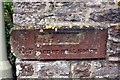
Old Boundary Marker by Cutpurse Lane, Richmond parish
Estate Boundary Marker - War Department by the UC road, in parish of Richmond (Richmondshire District), Cutpurse Lane, in wall of former barracks.
See https://www.geograph.org.uk/photo/5313381 for wider view.
Surveyed
Milestone Society National ID: YN_WDRICB07em
Image: © Roger Templeman
Taken: Unknown
0.05 miles
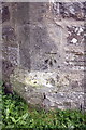
2
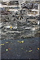
Benchmark on wall of Cutpurse Lane
Ordnance Survey cut mark benchmark described on the Bench Mark Database at http://www.bench-marks.org.uk/bm78241
Image: © Roger Templeman
Taken: 18 Aug 2016
0.05 miles
3
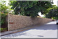
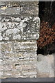
Boundary wall of former infantry barracks, Cutpurse Lane
The boundary marker stone at the wall angle bears the inscription 'No. 7 FACE OF WALL NORTH'. There is an OS benchmark Image on the wall about 5m right of the wall angle.
Image: © Roger Templeman
Taken: 18 Aug 2016
0.06 miles
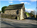
4
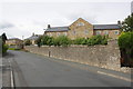
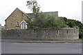
Housing provided by converted barracks, Beechfield Road
There is an OS benchmark Image on the inscribed stone inserted in the wall end near the right hand side of the image
Image: © Roger Templeman
Taken: 23 Aug 2012
0.18 miles
5
Benchmark on wall angle next to #21 Beechfield Road
The Ordnance Survey cut mark benchmark is on an inscribed stone (the last word is 'SOUTH') and is described on the Bench Mark Database at http://www.bench-marks.org.uk/bm44984
Image: © Roger Templeman
Taken: 23 Aug 2012
0.19 miles
6
Northwest angle of wall around former barracks, Cutpurse Lane
There is an OS benchmark Image on the inscribed stone
Image: © Roger Templeman
Taken: 23 Aug 2012
0.19 miles
7
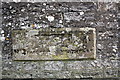
Benchmarked inscribed stone in wall of Cutpurse Lane
The wall is the north west angle of the boundary wall of the former barracks, and the inscription is 'No. 2 FACE OF WALL NORTH WEST'. The Ordnance Survey cut mark benchmark is described on the Bench Mark Database at http://www.bench-marks.org.uk/bm45609
Image: © Roger Templeman
Taken: 23 Aug 2012
0.19 miles
9
Richmond Milestone
This milestone on Gilling Road is believed to have been inscribed, "Lucy Cross 7" miles (on the side in shadow) and "Richmond 1" mile (on the sunny side).
Image: © David Rogers
Taken: 10 Mar 2009
0.21 miles
10
Benchmark on tower at Gallowgate entrance to former barracks
Ordnance Survey cut mark benchmark described on the Bench Mark Database at http://www.bench-marks.org.uk/bm44131
Image: © Roger Templeman
Taken: 23 Aug 2012
0.21 miles