IMAGES TAKEN NEAR TO
Delight Court, STANLEY, DH9 9XJ
Introduction
This page details the photographs taken nearby to Delight Court, DH9 9XJ by members of the Geograph project.
The Geograph project started in 2005 with the aim of publishing, organising and preserving representative images for every square kilometre of Great Britain, Ireland and the Isle of Man.

There are currently over 7.5m images from over14,400 individuals and you can help contribute to the project by visiting https://www.geograph.org.uk
Image Map
Images are licensed for reuse under creativecommons.org/licenses/by-sa/2.0
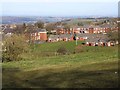
Notes
- Clicking on the map will re-center to the selected point.
- The higher the marker number, the further away the image location is from the centre of the postcode.
Image Listing (19 Images Found)
Images are licensed for reuse under creativecommons.org/licenses/by-sa/2.0
Image
Details
Distance
1
Delight Court, Dipton
Modern housing at Dipton.
Image: © Oliver Dixon
Taken: 28 Feb 2014
0.01 miles
2
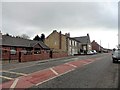
Looking along Front Street
View SW up Front Street, the main street which runs through the village. The short row opposite is Bowes Terrace, named after one of the principal coal owning families in this part of Co Durham. Dipton was a prime example of a colliery village back in the nineteenth and early twentieth centuries.
Image: © Robert Graham
Taken: 20 Mar 2019
0.06 miles
3
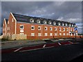
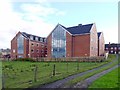
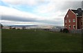
Dipton Manor Care Home, Front Street, Dipton
The 70 bedroom Care Home was built by North-East Comedian, Bobby Pattinson, on the site of the former Bute Arms public house which was badly damaged by fire in 2007. It opened in the new year of 2013. The home caters for people with dementia as well as provide ordinary nursing care and provides extensive views over the Derwent Valley as far north as the Cheviot Hills.
The rear of the new building is shown here Image
Image: © Andrew Curtis
Taken: 26 Oct 2013
0.07 miles
4
Dipton Manor Care Home, Front Street, Dipton
The front of the building is shown here Image
Image: © Andrew Curtis
Taken: 26 Oct 2013
0.07 miles
5
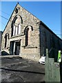
Aladdins Church
Second-hand furniture shop housed in an old church on Front Street, Dipton.
Image: © Oliver Dixon
Taken: 27 Jan 2022
0.07 miles
6
Delight Row & Wordsworth Gardens, Dipton
Image: © Andrew Curtis
Taken: 7 Jan 2011
0.08 miles
7
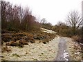
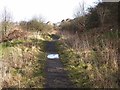
Path east of Dipton
The site of Vane Pit is overgrown on the left. This coal mine was opened in 1740.
Image: © Andrew Curtis
Taken: 7 Jan 2011
0.11 miles
8
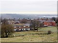
Open space on Front Street, Dipton
This open area in the centre of the village is used as a playing field. The gap in the built up area gives great views to the NW across the Derwent Valley. The building on the right is Dipton Manor Care Home, which was built recently on the site of the old Bute Arms pub.
Image: © Robert Graham
Taken: 20 Mar 2019
0.13 miles
9
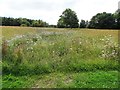
Wild flower plot at Dipton
This is beside Front Street, towards the northern end of the village. I think this was once the site of the gas works. These wild flower meadows are becoming quite popular in this area of County Durham, and have a lot to recommend them. Once created, they only need cutting and raking once a year, and should be self seeding. Much nicer than sterile mowed grass.
Image: © Robert Graham
Taken: 3 Aug 2020
0.13 miles
10
Footpath below North Road, Flint Hill
It seems very possible that this footpath follows the track of an old mineral railway.
Image: © Oliver Dixon
Taken: 28 Feb 2014
0.16 miles