IMAGES TAKEN NEAR TO
Bushblades Mews, STANLEY, DH9 9UF
Introduction
This page details the photographs taken nearby to Bushblades Mews, DH9 9UF by members of the Geograph project.
The Geograph project started in 2005 with the aim of publishing, organising and preserving representative images for every square kilometre of Great Britain, Ireland and the Isle of Man.

There are currently over 7.5m images from over14,400 individuals and you can help contribute to the project by visiting https://www.geograph.org.uk
Image Map
Images are licensed for reuse under creativecommons.org/licenses/by-sa/2.0
Notes
- Clicking on the map will re-center to the selected point.
- The higher the marker number, the further away the image location is from the centre of the postcode.
Image Listing (9 Images Found)
Images are licensed for reuse under creativecommons.org/licenses/by-sa/2.0
Image
Details
Distance
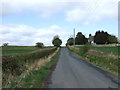
1
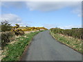
View SE from near the top of Bushblades Lane
View from just below High Bushblades. Bush Blades farm in the middle distance, Stanley on the horizon.
Image: © Robert Graham
Taken: 9 Mar 2012
0.02 miles
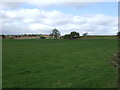
2
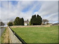
The main house at Bush Blades
This is the main farmhouse of this large 19th century farm complex. The former labourers cottages and some of the barns have been converted into modern houses and apartments.
Image: © Robert Graham
Taken: 9 Mar 2012
0.04 miles