IMAGES TAKEN NEAR TO
South View, STANLEY, DH9 9UE
Introduction
This page details the photographs taken nearby to South View, DH9 9UE by members of the Geograph project.
The Geograph project started in 2005 with the aim of publishing, organising and preserving representative images for every square kilometre of Great Britain, Ireland and the Isle of Man.

There are currently over 7.5m images from over14,400 individuals and you can help contribute to the project by visiting https://www.geograph.org.uk
Image Map
Images are licensed for reuse under creativecommons.org/licenses/by-sa/2.0
Notes
- Clicking on the map will re-center to the selected point.
- The higher the marker number, the further away the image location is from the centre of the postcode.
Image Listing (45 Images Found)
Images are licensed for reuse under creativecommons.org/licenses/by-sa/2.0
Image
Details
Distance
1
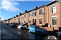
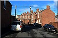
South View, Tantobie
A long terrace of houses on South View in Tantobie.
Image: © Graham Robson
Taken: 28 Oct 2018
0.01 miles
2
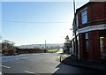
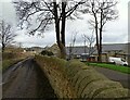
Road junction at the bottom of South View
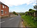
At the east end of Tantobie village, this is the junction of South View with the B6173, the main road to Stanley. The town of Stanley can be seen in the distance.
Image: © Robert Graham
Taken: 24 Jan 2022
0.01 miles
3
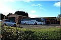
Coach operator's yard, Tantobie
Two coaches are parked among the buildings of a yard on South View in Tantobie.
Image: © Graham Robson
Taken: 28 Oct 2018
0.02 miles
4
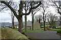
Tanfield Leith Farm
Freshly built walls bounding the entrance to the farm at Tanfield Leith.
Image: © Graham Robson
Taken: 28 Oct 2018
0.07 miles
5
Looking down South View bank, Tantobie
Tantobie village is built on a slope leading up from the Stanley road, the B6173. When I lived near here in the 1950's, this road was always called "Kitty Reed's Bank", although I never knew why.
Image: © Robert Graham
Taken: 14 May 2014
0.08 miles
6
Owen Terrace, Tantobie
The rear of the terrace of houes on Owen Terrace seen from South View.
Image: © Graham Robson
Taken: 28 Oct 2018
0.08 miles
7
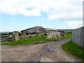
Old outbuildings at Tanfield Leith Farm
Dilapidated shed, but looks old and interesting. The lane here was once the main route between the villages of Tantobie and Tanfield Lea.
Image: © Robert Graham
Taken: 14 May 2014
0.10 miles
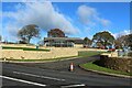
8
Rear view of Tanfield Leith Farm
This old farm near Tantobie village dates in part to the 17th century. I would think most of the surviving buildings here are early 19th century, but the main house, on the right here, has earlier origins. There has been extensive and sensitive restoration recently.
Image: © Robert Graham
Taken: 6 Mar 2023
0.11 miles
9
Lane behind Tanfield Leith farm
This lane behind the farm is now only an access road, but was once the main road between the villages of Tantobie and Tanfield Lea. This latter village can be seen in the distance.
Image: © Robert Graham
Taken: 6 Mar 2023
0.11 miles
10
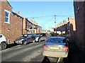
Steep terraces at Tantobie
These old terraced streets run up the steep slope between South View and Front Street in the village.
Image: © Robert Graham
Taken: 24 Jan 2022
0.12 miles