IMAGES TAKEN NEAR TO
White-le-Head, STANLEY, DH9 9SF
Introduction
This page details the photographs taken nearby to White-le-Head, DH9 9SF by members of the Geograph project.
The Geograph project started in 2005 with the aim of publishing, organising and preserving representative images for every square kilometre of Great Britain, Ireland and the Isle of Man.

There are currently over 7.5m images from over14,400 individuals and you can help contribute to the project by visiting https://www.geograph.org.uk
Image Map
Images are licensed for reuse under creativecommons.org/licenses/by-sa/2.0
Notes
- Clicking on the map will re-center to the selected point.
- The higher the marker number, the further away the image location is from the centre of the postcode.
Image Listing (13 Images Found)
Images are licensed for reuse under creativecommons.org/licenses/by-sa/2.0
Image
Details
Distance
1
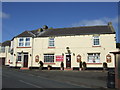
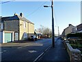
Former pub in White-le-Head
The white building on the left was formerly the Wagon Inn, although it was closed and converted into a private house quite a few years ago. The building next to it is the Bird Inn.
Image: © Robert Graham
Taken: 9 Mar 2012
0.11 miles
3
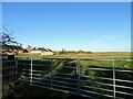
Field gate at White-le-Head
By the side of West Road, the main road through this little mining village. The bungalows are part of Alder Crescent.
Image: © Robert Graham
Taken: 24 Jan 2022
0.11 miles
4

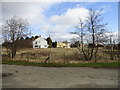
Site of East Bushblades
The remains here of old walls and hedges are all that is left of the farmstead of East Bushblades. Although I have been familiar with this spot since the 1950's, it wasn't until recently that I looked at the 1862 First Series Ordnance Survey map and realised there had been a farm here long ago.
Image: © Robert Graham
Taken: 9 Apr 2014
0.12 miles
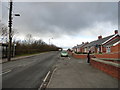
6
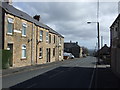
West Road, White-le-Head
View looking east down the main street of this little ex-mining village.
Image: © Robert Graham
Taken: 24 Jan 2022
0.16 miles
7
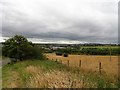
View south over old common land near Flint Hill
The grassland here has always been rough grazing. The old road on the left was the access road to a small colliery called the North Pit, an outlier of the larger Tanfield Lea Colliery. The site is now occupied by the modern farmstead of Low Wyndways Farm, in the centre of the picture. There is a nice view across the valley to Annfield Plain.
Image: © Robert Graham
Taken: 24 Jul 2018
0.17 miles
8
Fern Terrace, White-le-Head
These little bungalows were built before the last war by Stanley Council. The bus which can be seen disappearing down the road is interesting. It is the Flint Hill to Stanley service operated by Hunters bus company and is reputed to be the oldest continuously operated bus service in the world. It was started by Hunters in the nineteen twenties and they have run it ever since.
Image: © Robert Graham
Taken: 9 Mar 2012
0.20 miles
9
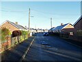
Bungalows at White-le-Head
This is Alder Crescent, a small estate of council bungalows built between the wars in this little ex-mining village.
Image: © Robert Graham
Taken: 24 Jan 2022
0.20 miles
10
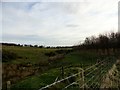
Rough grassland
An area of rough pasture with a little stream running through south of White-le-Head.
Image: © Robert Graham
Taken: 30 Nov 2016
0.21 miles