IMAGES TAKEN NEAR TO
Westhills, STANLEY, DH9 9RZ
Introduction
This page details the photographs taken nearby to Westhills, DH9 9RZ by members of the Geograph project.
The Geograph project started in 2005 with the aim of publishing, organising and preserving representative images for every square kilometre of Great Britain, Ireland and the Isle of Man.

There are currently over 7.5m images from over14,400 individuals and you can help contribute to the project by visiting https://www.geograph.org.uk
Image Map
Images are licensed for reuse under creativecommons.org/licenses/by-sa/2.0
Notes
- Clicking on the map will re-center to the selected point.
- The higher the marker number, the further away the image location is from the centre of the postcode.
Image Listing (36 Images Found)
Images are licensed for reuse under creativecommons.org/licenses/by-sa/2.0
Image
Details
Distance
1
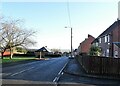
Bus stop on West Road
On the main road through the little ex-mining village of Whit-le-Head.
Image: © Robert Graham
Taken: 24 Jan 2022
0.05 miles
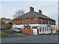
2
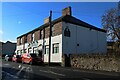
The Commercial, Tantobie
This pub on Front Street in the village obviously takes its name from the days when commercial travellers toured the country and needed overnight accommodation.
Image: © Robert Graham
Taken: 14 May 2014
0.07 miles
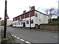
3
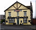
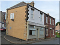
The ********** Hotel, Tantobie
One gets quite used to the odd letter missing from pub names, but here the entire name seems to be missing from the Commercial Hotel in Front Street, Tantobie.
Image: © Oliver Dixon
Taken: 31 Oct 2014
0.07 miles
4
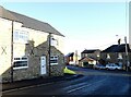
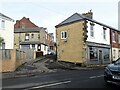
Junction of two villages
This is the bottom of West Road in White-le-Head, where it becomes Front Street in Tantobie, on the left. These are two little ex-mining villages near Stanley.
Image: © Robert Graham
Taken: 24 Jan 2022
0.07 miles
5
The Commerical Hotel, Front Street, Tantobie
A pub on Front Street, the signage on the front of the building was in need of a little TLC as a loss of lettering from the pub's name meant it had been reduced to 'The'.
Image: © Graham Robson
Taken: 28 Oct 2018
0.08 miles
8
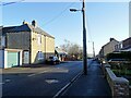
Old streets in Tantobie
Tantobie is a mainly late 19th century former mining village in Co Durham. This is the junction of Chapel Street with Front Street in the centre of the village. The steep bank is typical, as the village is built on a hillside.
Image: © Robert Graham
Taken: 6 Mar 2023
0.09 miles
9
"The Olive Stone", Tantobie
Quite a surprise to find an Italian bakers here on Front Street, Tantobie.
Image: © Oliver Dixon
Taken: 31 Oct 2014
0.10 miles
10
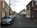
West Road, White-le-Head
View looking east down the main street of this little ex-mining village.
Image: © Robert Graham
Taken: 24 Jan 2022
0.11 miles