IMAGES TAKEN NEAR TO
Parkside, STANLEY, DH9 9NR
Introduction
This page details the photographs taken nearby to Parkside, DH9 9NR by members of the Geograph project.
The Geograph project started in 2005 with the aim of publishing, organising and preserving representative images for every square kilometre of Great Britain, Ireland and the Isle of Man.

There are currently over 7.5m images from over14,400 individuals and you can help contribute to the project by visiting https://www.geograph.org.uk
Image Map
Images are licensed for reuse under creativecommons.org/licenses/by-sa/2.0
Notes
- Clicking on the map will re-center to the selected point.
- The higher the marker number, the further away the image location is from the centre of the postcode.
Image Listing (43 Images Found)
Images are licensed for reuse under creativecommons.org/licenses/by-sa/2.0
Image
Details
Distance
1

Parkside estate, Tanfield Lea
This estate was built as council housing in the post war period. Probably in the 1960's or a little later.
Image: © Robert Graham
Taken: 24 Jan 2022
0.02 miles
2

Parkside Estate, Tanfield Lea
Tanfield Lea is a former mining village dating mainly from the 19th and early 20th centuries. This estate, on the western side, was built in the 1950's as council housing.
Image: © Robert Graham
Taken: 6 Mar 2023
0.03 miles
3
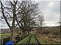
Trackside trees at Tanfield Lea
Winter trees alongside the farm track from Tanfield Leith to the village of Tanfield Lea. The estate ahead is Parkside, built in the 1950's as council housing.
Image: © Robert Graham
Taken: 6 Mar 2023
0.04 miles
4
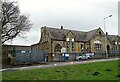
Tanfield Lea Primary School
This was originally built in 1893 as The Tanfield Board School.
Image: © Robert Graham
Taken: 6 Mar 2023
0.05 miles
5
Line of the old railway at Tanfield Lea
This path on the left here, on the east side of the B6173, is on the line of an old colliery railway. It ran between the collieries of White-le-Head and Tanfield Lea and closed in the 1940's. There were no railway engines used - the coal trucks were pulled by a continuous wire rope, operated by gravity, I believe.
Image: © Robert Graham
Taken: 24 Jan 2022
0.05 miles
6

Bus at Tanfield Lea
This is the Stanley Travel service No 713 on its way from Stanley to Tantobie. The service follows a circular route through the local villages taking in Tanfield Lea, Tantobie, Flint Hill, Dipton and Annfield Plain among others.
Image: © Robert Graham
Taken: 6 Mar 2023
0.06 miles
7
Route of a former railway at Tanfield Lea
This farm track on the west side of Tanfield Lea village is on the route of a former railway line. It was the LNER's Tanfield Branch and operated for coal traffic from the Tanfield Moor Colliery at White-le-Head down to Tanfield and East Tanfield Collieries and on to Gateshead and the River Tyne. This top section was closed in 1947 after the closure of Tanfield Moor Colliery. The line was lifted long ago, but the route remains.
Image: © Robert Graham
Taken: 6 Mar 2023
0.06 miles
8
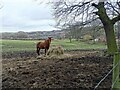
Horse grazing at Tanfield Lea
Grazing field on the western edge of the village. Tanfield Leith farm, nearby, seems to be mainly a horsey establishment. The village houses can be seen on the right.
Image: © Robert Graham
Taken: 6 Mar 2023
0.07 miles
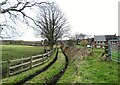
9
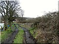
Gate across the farm track
This track leads from Tanfield Leith farm to the village of Tanfield Lea. It is also a public path, as can be seen from the provision of a stile.
Image: © Robert Graham
Taken: 6 Mar 2023
0.08 miles
10

King Edward Street, Tanfield Lea
This street of sturdy ex miners houses obviously dates from the early 20th century, judging from the name.
Image: © Robert Graham
Taken: 11 Jul 2012
0.09 miles