IMAGES TAKEN NEAR TO
Dipton, STANLEY, DH9 9BF
Introduction
This page details the photographs taken nearby to DH9 9BF by members of the Geograph project.
The Geograph project started in 2005 with the aim of publishing, organising and preserving representative images for every square kilometre of Great Britain, Ireland and the Isle of Man.

There are currently over 7.5m images from over14,400 individuals and you can help contribute to the project by visiting https://www.geograph.org.uk
Image Map
Images are licensed for reuse under creativecommons.org/licenses/by-sa/2.0
Notes
- Clicking on the map will re-center to the selected point.
- The higher the marker number, the further away the image location is from the centre of the postcode.
Image Listing (29 Images Found)
Images are licensed for reuse under creativecommons.org/licenses/by-sa/2.0
Image
Details
Distance
1

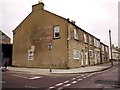
Former Red Lion pub
A striking Edwardian structure at the junction of Cooperative Terrace with Front Street.
Image: © Oliver Dixon
Taken: 27 Jan 2022
0.04 miles
2

Former Red Lion pub, Dipton
On the corner of Front Street and Co-operative Terrace, the disused pub was for a time a shrine to Sapper Daryn Roy killed in a roadside bomb in Afghanistan on May 3rd 2010. A sign in the boarded up windows reads, "Daryn Roy. Dipton hero"
http://www.chroniclelive.co.uk/north-east-news/evening-chronicle-news/2010/05/19/dipton-pay-tribute-to-tragic-soldier-daryn-roy-72703-26475933/
Image: © Andrew Curtis
Taken: 7 Jan 2011
0.04 miles
3

Front Street, Dipton
The very busy A692.
Image: © Oliver Dixon
Taken: 27 Jan 2022
0.04 miles
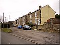
4

Co-operative Terrace, Dipton
Showing the Post Office and Club on the south side of the street, opposite the shops.
Image: © Andrew Curtis
Taken: 7 Jan 2011
0.04 miles
5
Front Street, Dipton from junction with Co-operative Terrace
London House is on the corner, opposite the former Red Lion pub.
Image: © Andrew Curtis
Taken: 7 Jan 2011
0.05 miles
6

Collierley Primary School, Dipton
The village school first opened in 1878 as Colliery Board School. In those days, Dipton referred to the northern end of the village only, and the southern part was called Collierley.
Image: © Robert Graham
Taken: 11 Apr 2022
0.08 miles
7
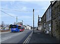
Bus on Front Street, Dipton
A No 16 bus going north along the A692. This Go Northeast service goes to Durham city from Consett, although on a very roundabout route via Dipton, Stanley and Sacriston.
Image: © Robert Graham
Taken: 11 Apr 2022
0.08 miles
9
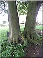
Dinosaur?
These sycamore trees shared a large root. They look like the legs and toes of some giant prehistoric animal.
Image: © Christine Westerback
Taken: 28 May 2006
0.09 miles
10
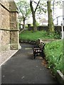
Seat
I couldn't resist taking this bench which was facing a blank stone wall. If it had been turned 45 degrees and brought slightly forward it could have had this view Image
Image: © Christine Westerback
Taken: 28 May 2006
0.09 miles