IMAGES TAKEN NEAR TO
Pontop Pike Lane, STANLEY, DH9 9AP
Introduction
This page details the photographs taken nearby to Pontop Pike Lane, DH9 9AP by members of the Geograph project.
The Geograph project started in 2005 with the aim of publishing, organising and preserving representative images for every square kilometre of Great Britain, Ireland and the Isle of Man.

There are currently over 7.5m images from over14,400 individuals and you can help contribute to the project by visiting https://www.geograph.org.uk
Image Map
Images are licensed for reuse under creativecommons.org/licenses/by-sa/2.0
Notes
- Clicking on the map will re-center to the selected point.
- The higher the marker number, the further away the image location is from the centre of the postcode.
Image Listing (40 Images Found)
Images are licensed for reuse under creativecommons.org/licenses/by-sa/2.0
Image
Details
Distance
1
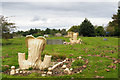
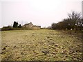
Cemetery near to Dipton
The cemetery, to the south of Dipton, has a rather neglected look yet the grass is clearly tended and has been cut recently. Pottery memorials of the type prominent in the image are quite common in County Durham and were presumably cast from a mould, so much cheaper to manufacture than stone monuments. The heart shaped plate carries the inscription which would be have been cast at the time of manufacture rather than cut afterwards.
Image: © Trevor Littlewood
Taken: 30 Sep 2017
0.05 miles
2
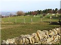
Cemetery on Pontop Pike Lane, Dipton
The two white headstones at the far end of the cemetery are Commonwealth War Graves.
Image: © Oliver Dixon
Taken: 28 Feb 2014
0.05 miles
3
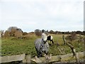
Inquisitive horse
Near Raisenside Farm, south of Pontop Pike Lane.
Image: © Robert Graham
Taken: 30 Nov 2016
0.08 miles
4
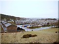
Houses on Delight Bank, Dipton
View from the ornate seat on the site of the former Delight Colliery.
Image: © Andrew Curtis
Taken: 7 Jan 2011
0.09 miles
5
Path to Raisenside Farm
The path is a continuation of the Stob Waggonway although little is now visible of its line.
Image: © Andrew Curtis
Taken: 7 Jan 2011
0.11 miles
6
Housing estate, Dipton
View of Tennyson Gardens from the site of the former Delight Colliery.
Image: © Andrew Curtis
Taken: 7 Jan 2011
0.12 miles
7
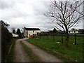
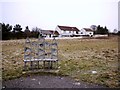
Entrance to Raisenside Farm, Dipton
Looking down the track from Pontop Pike Lane to the farm.
Image: © Robert Graham
Taken: 9 Apr 2014
0.13 miles
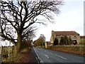
8
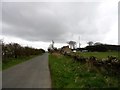
Looking up Pontop Pike Lane, Dipton
View south up the bank past Pontop Pike Lane End farm on the right. This lane was one of those established on the former Lanchester Common after the Enclosure Act of 1773 and is supposed to be one of the best preserved in original configuration.
Image: © Robert Graham
Taken: 9 Apr 2014
0.13 miles
9
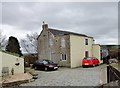
Farmhouse at Raisenside, Dioton
This farm is just south of Pontop Pike Lane in Dipton. It was one of those established after the Enclosures Act of 1773. The house probably dates from that time or a bit later, although it has been altered since.
Image: © Robert Graham
Taken: 9 Apr 2014
0.13 miles
10
Fondly Set farmhouse
On the lane of that name in Dipton. The road is however more commonly known as The Avenue, because of the line of Beech trees down it.
Image: © Robert Graham
Taken: 30 Nov 2016
0.14 miles