IMAGES TAKEN NEAR TO
Cemetery Lane, STANLEY, DH9 8DU
Introduction
This page details the photographs taken nearby to Cemetery Lane, DH9 8DU by members of the Geograph project.
The Geograph project started in 2005 with the aim of publishing, organising and preserving representative images for every square kilometre of Great Britain, Ireland and the Isle of Man.

There are currently over 7.5m images from over14,400 individuals and you can help contribute to the project by visiting https://www.geograph.org.uk
Image Map
Images are licensed for reuse under creativecommons.org/licenses/by-sa/2.0
Notes
- Clicking on the map will re-center to the selected point.
- The higher the marker number, the further away the image location is from the centre of the postcode.
Image Listing (8 Images Found)
Images are licensed for reuse under creativecommons.org/licenses/by-sa/2.0
Image
Details
Distance
1

Church of St Thomas at Harelaw
Harelaw is a little former mining village near Stanley. The church was built in 1840, probably because of expanding population working in the coal industry. It is by G Jackson, in the Early English style.
Image: © Robert Graham
Taken: 23 May 2013
0.05 miles
2

Rosedale Manor, Harelaw
This fine old house isn't actually a manor; it was built in 1840 as the vicarage for the village of Harelaw. It looks a very grand vicarage for a little village, but in those days Harelaw was a more important place than it is today. It was originally part of the Township of Kyo, which dates from the early middle ages. Many of the surrounding villages didn't exist then; they date only from the 18th or 19th centuries and the start of the coalmining industry.
Image: © Robert Graham
Taken: 23 May 2013
0.07 miles
3
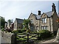
Old school buildings at Harelaw
In the foreground is the former schoolmaster's house (dated 1886), beyond is the school itself (dated 1846). At the far end of the row is Phoenix Court, modern houses sympathetically built in the same style.
Image: © Oliver Dixon
Taken: 11 Jul 2022
0.10 miles
4
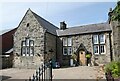
Old School House, Harelaw
The inscription over the door reads "1846 National School". The school closed in 1963 and subsequently fell into disrepair (see Image), but has been restored at some point since 2013.
Image: © Oliver Dixon
Taken: 11 Jul 2022
0.11 miles
5

Former village school, Harelaw
Harelaw is a former mining village near Stanley. The school was built in 1846 as the Collierley National School by the Church of England. In 1886 it was transferred to the new Kyo School Board and became Harelaw Council School. It was also enlarged and a new schoolmaster's house added. The school closed in 1963.
Image: © Robert Graham
Taken: 23 May 2013
0.13 miles
6

Former schoolmaster's house, Harelaw
This was built in 1886, when the school was transferred to the Kyo School Board and enlarged. It was sold off as a private dwelling when the school closed in 1963.
Image: © Robert Graham
Taken: 23 May 2013
0.15 miles
7

Roadside flowerbed
On the Annfield Plain/Dipton border beside the B6168. The bus is emerging from Fondlyset Lane.
Image: © Oliver Dixon
Taken: 11 Jul 2022
0.21 miles
8
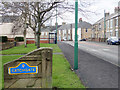
Catchgate
Catchgate is a former 'pit village' of County Durham which has all but merged with adjacent villages to form a larger built-up area. The road sign naming the settlement, (typical of a certain style in the county), is attached to a piece of rock carved in the form of a gate with a catch.
Image: © Trevor Littlewood
Taken: 13 Dec 2018
0.23 miles