IMAGES TAKEN NEAR TO
Mitchell Street, STANLEY, DH9 7SX
Introduction
This page details the photographs taken nearby to Mitchell Street, DH9 7SX by members of the Geograph project.
The Geograph project started in 2005 with the aim of publishing, organising and preserving representative images for every square kilometre of Great Britain, Ireland and the Isle of Man.

There are currently over 7.5m images from over14,400 individuals and you can help contribute to the project by visiting https://www.geograph.org.uk
Image Map
Images are licensed for reuse under creativecommons.org/licenses/by-sa/2.0
Notes
- Clicking on the map will re-center to the selected point.
- The higher the marker number, the further away the image location is from the centre of the postcode.
Image Listing (32 Images Found)
Images are licensed for reuse under creativecommons.org/licenses/by-sa/2.0
Image
Details
Distance
2
C2C at Annfield Plain
Land on the trackbed of the former Consett and Sunderland railway at Annfield Plain was sold off for housing, but a narrow pathway was retained alongside to carry the C2C (National Cycle Network route 7).
Image: © Oliver Dixon
Taken: 11 Jul 2022
0.08 miles
4
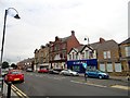
Front Street in Annfield Plain
A view looking north along the village main street from the corner of West Road. The big building in the centre is The Queens Head Hotel. The building on the right was once a bank, one of two bank branches in the village. Both now closed, unfortunately.
Image: © Robert Graham
Taken: 24 Jul 2018
0.09 miles
5
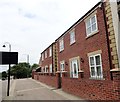
New houses on Front Street
In the centre of Annfield Plain, at the north end of the main street. These houses were built a few years ago on the site of a famous old pub which unfortunately burned down. It was called the Stanhope and Tyne Railway Inn and was built in the 1830's when the railway opened. There was very little else in Annfield Plain at the time. The village name came from the inclined plane up the Loud Bank where a steam engine hauled the trucks up the slope on a wire rope.
Image: © Robert Graham
Taken: 24 Jul 2018
0.09 miles
6
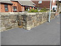
Station Road Bridge abutment
The large, well dressed stones and angles in this front garden wall are the only indications that this is all that remains of the north east abutment of Station Road Bridge, which carried the Birtley, Annfield Plain and Consett railway over the northwest end of Durham Road adjacent to the junction with Station Road and Spring Close.
The former railway is now only used by walkers, cyclists and horse riders exercising on the Consett and Sunderland Railway Path.
There is an Ordnance Survey cut benchmark on one of the large stone quoins on the face of the wall (detail photograph Image).
Image: © Adrian Taylor
Taken: 10 Aug 2020
0.09 miles
7
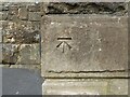
Benchmark, Station Road Bridge
Detail of the Ordnance Survey cut benchmark on the northeast buttress of Station Road Bridge in Annfield Plain. The benchmark marks a height of 235.6683m above mean sea level (Ordnance Datum Newlyn), last verified in 1962 (location photograph Image).
Image: © Adrian Taylor
Taken: 10 Aug 2020
0.09 miles
9
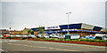
Superstore on site of Annfield Plain station?
View SW, probably on the B6168 road. The station had been where the superstore is, or just behind it. It had been on the line to Consett from Newcastle via Birtley and Ouston Junction and closed to passengers on 23/5/55 (goods 10/8/64). The line through Annfield Plain had remained active for the iron ore traffic from Tyne Dock via South Pelaw Junction, until Consett Ironworks closed in 9/80.
Image: © Ben Brooksbank
Taken: 20 Jun 2000
0.10 miles
10
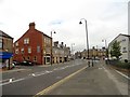
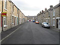
Station Road in Annfield Plain
Looking west along to the crossroads with West Road on the left and Front Street on the right. The street leading down from the left is Northgate. This is the centre of this former mining village.
Image: © Robert Graham
Taken: 24 Jul 2018
0.10 miles