IMAGES TAKEN NEAR TO
Lintz Terrace, STANLEY, DH9 7LH
Introduction
This page details the photographs taken nearby to Lintz Terrace, DH9 7LH by members of the Geograph project.
The Geograph project started in 2005 with the aim of publishing, organising and preserving representative images for every square kilometre of Great Britain, Ireland and the Isle of Man.

There are currently over 7.5m images from over14,400 individuals and you can help contribute to the project by visiting https://www.geograph.org.uk
Image Map
Images are licensed for reuse under creativecommons.org/licenses/by-sa/2.0
Notes
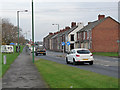
- Clicking on the map will re-center to the selected point.
- The higher the marker number, the further away the image location is from the centre of the postcode.
Image Listing (28 Images Found)
Images are licensed for reuse under creativecommons.org/licenses/by-sa/2.0
Image
Details
Distance
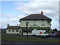
2
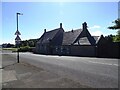
The Ox Inn, Oxhill
This pub is shown on the 1862 O S map as "The Bull", but had changed to the present name on the 1899 revision. The area in front here was the location of a level crossing where the railway went across Shieldrow Lane.
Image: © Robert Graham
Taken: 8 Jul 2024
0.02 miles
3
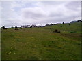
View towards the Ox Inn
Looking South from the railway path across a rough grass field which is good for wild flowers.
Image: © Robert Graham
Taken: 1 Jun 2011
0.02 miles
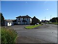
4
The Ox Inn, Oxhill, Stanley
A public house just off the A693 in Oxhill.
Image: © Graham Robson
Taken: 28 Oct 2018
0.03 miles
5
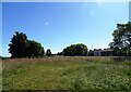
Wild flower meadow at Oxhill
For a few years now, the local Council has maintained a wild flower strip here between The Ox Inn and Oxhill Nursery school. A good spot for one, as the soil will be poor as this was once a row of terraced houses. The meadow is past its best here in mid summer; mostly gone to seed.
Image: © Robert Graham
Taken: 8 Jul 2024
0.04 miles
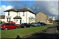
6
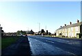
Start of the Annfield Plain by-pass
The by-pass on the A693 starts here at Oxhill, on the left here. The original road can be seen in the centre, to the right of the former Methodist Chapel. Lintz Terrace is on the right. Originally, this was the site of a level crossing for the colliery line to the Louisa pit at Stanley.
Image: © Robert Graham
Taken: 24 Jan 2022
0.04 miles
8
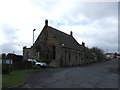
Former chapel from the west
Looking along Shieldrow Lane to Oxhill. The Methodist chapel opened in 1874 and closed about 1977. It was then sold off and converted to a private house.
Image: © Robert Graham
Taken: 8 Jul 2024
0.05 miles
9
A693 entering Oxhill
The busy A693 which runs from Castleside to Chester-le-Street at the western boundary of Oxhill, a suburb of Stanley.
Image: © Oliver Dixon
Taken: 31 Oct 2014
0.05 miles
10
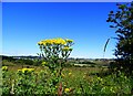
Ragwort on the heath
Wild flowers on the heathland at Oxhill. The yellow flowers are Common Ragwort.
Image: © Robert Graham
Taken: 8 Jul 2024
0.05 miles