IMAGES TAKEN NEAR TO
Annfield Plain, STANLEY, DH9 7HU
Introduction
This page details the photographs taken nearby to DH9 7HU by members of the Geograph project.
The Geograph project started in 2005 with the aim of publishing, organising and preserving representative images for every square kilometre of Great Britain, Ireland and the Isle of Man.

There are currently over 7.5m images from over14,400 individuals and you can help contribute to the project by visiting https://www.geograph.org.uk
Image Map
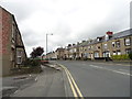
Images are licensed for reuse under creativecommons.org/licenses/by-sa/2.0
Notes
- Clicking on the map will re-center to the selected point.
- The higher the marker number, the further away the image location is from the centre of the postcode.
Image Listing (24 Images Found)
Images are licensed for reuse under creativecommons.org/licenses/by-sa/2.0
Image
Details
Distance
1
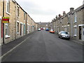
Shieldrow Lane, New Kyo
Looking west from the junction with Croft Terrace. Shieldrow Lane is the main road from Annfield Plain to Stanley. The houses of South View are on the right.
Image: © Robert Graham
Taken: 12 Jul 2017
0.03 miles
2
South View , New Kyo
New Kyo forms the eastern end of Annfield Plain. This is the west end of Shieldrow Lane, the main road to Stanley. This terrace is probably Edwardian in date, and with its curved brick soldier arches and door and window surrounds has an original look to it.
Image: © Robert Graham
Taken: 12 Jul 2017
0.04 miles
3
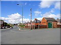
The Morrison Road Ends
This road junction at the east end of Annfield Plain takes its local name from the former Morrison Busty colliery which was on the road just south of here.
Image: © Robert Graham
Taken: 18 Jul 2012
0.04 miles
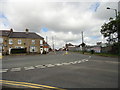
4
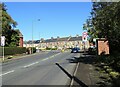
Approaching the crossroads at the Morrison Road Ends
The crossroads takes its local name from the Morrison pit which once stood near here. View is looking along Lanchester Road. The stone terrace of Durham Road dates from late Victorian & Edwardian times.
Image: © Robert Graham
Taken: 29 Sep 2020
0.06 miles
5
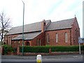
The Church of St Aidan, Annfield Plain
Image: © Bill Henderson
Taken: 14 Nov 2007
0.08 miles
6
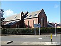
St Aidan's Church, Annfield Plain
Parish church built in 1928.
Image: © Robert Graham
Taken: 29 Sep 2020
0.08 miles
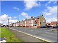
7
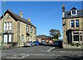
Houses on Durham Road
Long terraced row on the east side of the main village street in Annfield Plain. From old map evidence, the houses here seem to have been built piecemeal from late Victorian to Edwardian times. They do vary quite a lot in style.
Image: © Robert Graham
Taken: 29 Sep 2020
0.09 miles
8
Durham Road, Anfield Plain
Street of big Edwardian terraced houses on the east side of Annfield Plain.
Image: © Robert Graham
Taken: 18 Jul 2012
0.11 miles
9
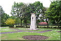
Annfield Plain War Memorial
War Memorial is located in the Annfield Plain Park. The monument commemorates WW1 and WW2.
Image: © John Charlton
Taken: 17 Jun 2006
0.14 miles