IMAGES TAKEN NEAR TO
Muriel Street, STANLEY, DH9 7EU
Introduction
This page details the photographs taken nearby to Muriel Street, DH9 7EU by members of the Geograph project.
The Geograph project started in 2005 with the aim of publishing, organising and preserving representative images for every square kilometre of Great Britain, Ireland and the Isle of Man.

There are currently over 7.5m images from over14,400 individuals and you can help contribute to the project by visiting https://www.geograph.org.uk
Image Map
Images are licensed for reuse under creativecommons.org/licenses/by-sa/2.0
Notes
- Clicking on the map will re-center to the selected point.
- The higher the marker number, the further away the image location is from the centre of the postcode.
Image Listing (19 Images Found)
Images are licensed for reuse under creativecommons.org/licenses/by-sa/2.0
Image
Details
Distance
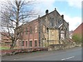
1
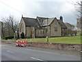
St George's Church, South Moor Road
Built in 1897.
Image: © Christine Johnstone
Taken: 14 Apr 2012
0.06 miles
2
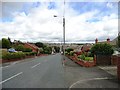
Looking down to South Moor
Looking from the top of the bank at Quaking Houses down the long straight stretch of Park Road through South Moor and up the other side of the bank to Stanley.
Image: © Robert Graham
Taken: 18 Jul 2012
0.08 miles
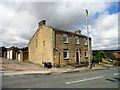
3
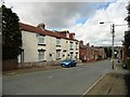
Former Stag Inn
This is the second of the pubs on Park Road at Quaking Houses. They are both now private houses, there is no pub in the village currently.
Image: © Robert Graham
Taken: 18 Jul 2012
0.09 miles
4

Memorial Park at South Moor
South Moor is in County Durham being adjacent to the larger town of Stanley. Memorial Park lies astride the Stanley Burn which can be seen at the right side of the image. The pale blue gates to the park form a war memorial "Erected by The South Moor Colliery Co. Ltd. in memory of their employees who fell in the Great War 1914 - 1919."
Image: © Trevor Littlewood
Taken: 1 May 2013
0.10 miles
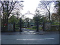
5
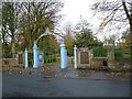
Entrance to the Memorial Park, South Moor
Established 1919, the list of the dead of World War 1 flank the gateway on either side. Smaller panels list the dead of World War 2.
Image: © Oliver Dixon
Taken: 31 Oct 2014
0.10 miles
6
The White House, Quaking Houses
This building standing at the top of the bank at Quaking Houses, was once a public house.
Image: © Robert Graham
Taken: 18 Jul 2012
0.11 miles
7
South Moor Park
Entrance gates to South Moor Memorial Park.
Image: © Bluespacecat
Taken: 26 Nov 2005
0.13 miles
8
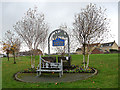
Village sign for Quaking Houses
This green corridor at the eastern end of the former mining village of Quaking Houses is on the site of the old coal mine. The old pit wheel can be seen in the background. The name possibly derives from being originally settled by Quakers, prior to the development of the mine.
Image: © Oliver Dixon
Taken: 31 Oct 2014
0.14 miles
9
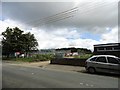
New school being built
A new school is being built here beside Park Road in South Moor to replace the old Greenland School in the village, which dates back to the early part of the last century.
Image: © Robert Graham
Taken: 18 Jul 2012
0.15 miles
10
Redundant place of worship, South Moor Road
Stone front, brick sides - kerb-side appeal on a restricted budget.
Image: © Christine Johnstone
Taken: 14 Apr 2012
0.15 miles