IMAGES TAKEN NEAR TO
Kneller Close, STANLEY, DH9 6TG
Introduction
This page details the photographs taken nearby to Kneller Close, DH9 6TG by members of the Geograph project.
The Geograph project started in 2005 with the aim of publishing, organising and preserving representative images for every square kilometre of Great Britain, Ireland and the Isle of Man.

There are currently over 7.5m images from over14,400 individuals and you can help contribute to the project by visiting https://www.geograph.org.uk
Image Map (Loading...)


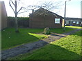
Getting Data...Please wait
Leaflet Map data © OpenStreetMap
Images are licensed for reuse under creativecommons.org/licenses/by-sa/2.0
Notes
- Clicking on the map will re-center to the selected point.
- The higher the marker number, the further away the image location is from the centre of the postcode.
Image Listing (33 Images Found)
Images are licensed for reuse under creativecommons.org/licenses/by-sa/2.0
Image
Details
Distance
1

Memorial erected on the site of Burns Pit Shaft, Stanley.
Image: © Philip Soakell
Taken: 1 Mar 2011
0.05 miles
2
The memorial erected on the site of the Burns Pit Shaft, Stanley.
Image: © Philip Soakell
Taken: 1 Mar 2011
0.05 miles
3
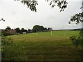
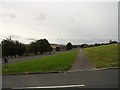
Playing fields at East Stanley
These are behind North Durham Academy, next to the schools own playing fields.
Image: © Robert Graham
Taken: 13 Sep 2019
0.10 miles
4
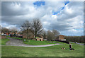
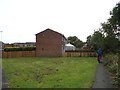
Grassed area with social housing in Stanley
The social housing of Brooks Close and Blakes Close would once have been known as council housing.
Image: © Trevor Littlewood
Taken: 10 Apr 2014
0.12 miles
5
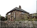
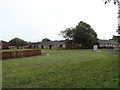
Stone house on East Stanley Estate
This house looks a bit out of place on this 1960's housing estate, but was here first. A plaque on the front wall states that it was built by William Bell in 1954-55, on what would have been an open site. Billy Bell was a well known local scrap man made good. The name Stanley Hall is taken from an old manor house which stood very near this spot from medieval times until the 1930's when it was demolished.
Image: © Robert Graham
Taken: 13 Sep 2019
0.13 miles
6
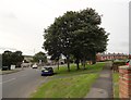
Looking west along Humber Hill road
This road in East Stanley joins Durham Road further on. The position here, on the side of the hill on which Stanley is built, gives good views of the surrounding countryside. The village of Quaking Houses can be made out in the distance.
Image: © Robert Graham
Taken: 13 Sep 2019
0.14 miles
7
Footpath at Arnold Close, East Stanley
The path here long predates the modern housing estate. It is shown on 19th century maps leading to the old farm of Stanley Hall, which used to be a manor house in the middle ages. It was demolished in the 1930's.
Image: © Robert Graham
Taken: 13 Sep 2019
0.15 miles
8
Chaucer Close, East Stanley
This is part of a large estate built at East Stanley by the council in the 1960's I think. All the streets are named after British poets and writers.
Image: © Robert Graham
Taken: 13 Sep 2019
0.16 miles
9
Approaching the road junction at the end of Humber Hill
This is the west end of Humber Hill. There is a major road junction here at the top end of South Stanley, with Durham Road going off to the left and Wear Road coming in from the right down the hill.
Image: © Robert Graham
Taken: 13 Sep 2019
0.16 miles
10
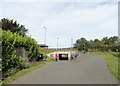
Pedestrian underpass at Stanley
This underpass at Reynolds Close at the top of South Stanley enables pedestrians to safely cross under the busy A693 by pass to access the town centre. The graffiti is not what it seems and is actually information.
Image: © Robert Graham
Taken: 13 Sep 2019
0.18 miles