IMAGES TAKEN NEAR TO
Landseer Close, STANLEY, DH9 6TA
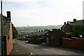
Introduction
This page details the photographs taken nearby to Landseer Close, DH9 6TA by members of the Geograph project.
The Geograph project started in 2005 with the aim of publishing, organising and preserving representative images for every square kilometre of Great Britain, Ireland and the Isle of Man.

There are currently over 7.5m images from over14,400 individuals and you can help contribute to the project by visiting https://www.geograph.org.uk
Image Map
Images are licensed for reuse under creativecommons.org/licenses/by-sa/2.0
Notes
- Clicking on the map will re-center to the selected point.
- The higher the marker number, the further away the image location is from the centre of the postcode.
Image Listing (31 Images Found)
Images are licensed for reuse under creativecommons.org/licenses/by-sa/2.0
Image
Details
Distance
1
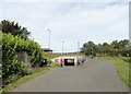
Pedestrian underpass at Stanley
This underpass at Reynolds Close at the top of South Stanley enables pedestrians to safely cross under the busy A693 by pass to access the town centre. The graffiti is not what it seems and is actually information.
Image: © Robert Graham
Taken: 13 Sep 2019
0.07 miles
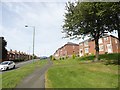
2
View down Wear Road, Stanley
Wear Road is the main road from Stanley town centre to the south. The large suburb of South Stanley starts here and continues down the slope of the hill. Houses were built in this area from the 1920's up until the present day.
Image: © Robert Graham
Taken: 13 Sep 2019
0.08 miles
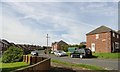
3
Looking up the hill at Wear Road
Wear Road is one of the main routes through the large suburb of South Stanley and this view gives a good indication of how the houses were built on the slopes of the hill. The view is from the east end of the road, near the junction with Durham Road.
Image: © Robert Graham
Taken: 13 Sep 2019
0.09 miles
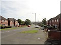
4
Road junction at South Stanley
This is the eastern end of Wansbeck Avenue at its junction with Wear Road. This is at the top end of the suburb of South Stanley, a large area of housing estates next to Stanley town centre.
Image: © Robert Graham
Taken: 13 Sep 2019
0.10 miles
5
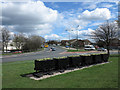
Rotary Way from the 'Asda Roundabout'
The centre of the town of Stanley is bypassed by the A693. The view is of a stretch of that road named Rotary Way and is seen from what is known as the 'Asda Roundabout'. The decorative coal tubs, in use as flower tubs, reflect the coal mining heritage of the area.
Image: © Trevor Littlewood
Taken: 10 Apr 2014
0.10 miles
6
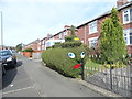
Thomas the Tank Hedge
An amusing piece of topiary on Wear Road, in South Stanley.
Image: © Robert Graham
Taken: 13 Sep 2019
0.11 miles
7
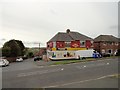
Corner shop on Wear Road, South Stanley
This local convenience store seems to be the equivalent of the old corner shop. On the corner with Tees Crescent.
Image: © Robert Graham
Taken: 13 Sep 2019
0.11 miles
8
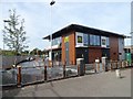
New McDonald's at Stanley
This McDonald's was opened earlier this year in 2019, and is the first one in Stanley town centre. It occupies the site of former government offices on Clifford Road.
Image: © Robert Graham
Taken: 13 Sep 2019
0.12 miles
9
South Stanley, Co. Durham
Taken near Tweed Terrace, view to South.
Image: © Gordon Fenwick
Taken: 10 Sep 2006
0.14 miles
10
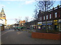
Stanley Front Street looking towards the Imperial Hotel
Image: © brian clark
Taken: 9 Jan 2007
0.14 miles