IMAGES TAKEN NEAR TO
Lowery Lane, STANLEY, DH9 6EN
Introduction
This page details the photographs taken nearby to Lowery Lane, DH9 6EN by members of the Geograph project.
The Geograph project started in 2005 with the aim of publishing, organising and preserving representative images for every square kilometre of Great Britain, Ireland and the Isle of Man.

There are currently over 7.5m images from over14,400 individuals and you can help contribute to the project by visiting https://www.geograph.org.uk
Image Map
Images are licensed for reuse under creativecommons.org/licenses/by-sa/2.0
Notes
- Clicking on the map will re-center to the selected point.
- The higher the marker number, the further away the image location is from the centre of the postcode.
Image Listing (25 Images Found)
Images are licensed for reuse under creativecommons.org/licenses/by-sa/2.0
Image
Details
Distance
1
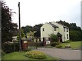
House on Lowery Lane, Craghead
This lane runs into Craghead village from the south. The dwelling is called Easfield House, which seems to be taken from an old terrace which used to stand further down the lane.
Image: © Robert Graham
Taken: 9 Sep 2019
0.02 miles
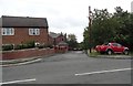
2
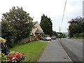
Top end of Lowery Lane
This is the road that leads into Craghead village from the south.
Image: © Robert Graham
Taken: 9 Sep 2019
0.02 miles
3

Former church at Craghead
This is St Thomas' Church, which was built in 1910-11. The village had expanded in the late C19 to accommodate miners working in the nearby collieries. It is now a private house.
Image: © Robert Graham
Taken: 9 Sep 2019
0.04 miles

5
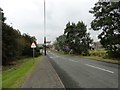
View down Lowery Lane, Craghead
This is the road into the village from the south, and the main route to Durham city from here. The house at the bottom of the bank is White House Farm.
Image: © Robert Graham
Taken: 9 Sep 2019
0.08 miles
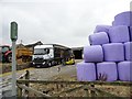
6
Happy Bales
Hay bales at White House Farm in Craghead painted with faces for charity.
Image: © Robert Graham
Taken: 9 Sep 2019
0.11 miles
7
Entrance to George Street, Craghead
This street runs behind Edward Street, the main street through the south side of the village. It is another of the late 19th century terraced streets in this ex mining village.
Image: © Robert Graham
Taken: 9 Sep 2019
0.13 miles
8
Busy farmyard at White House Farm
This farm is on Lowery Lane at the south end of Craghead village.
Image: © Robert Graham
Taken: 9 Sep 2019
0.13 miles
9
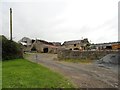
Old farm buildings at White House Farm
This old farmstead is at the top of Lowery Lane, leading into Craghead from the south. The farm buildings here look early Victorian in date. The farm was here long before the mining village of Craghead came into being in the later C19.
Image: © Robert Graham
Taken: 9 Sep 2019
0.14 miles
10
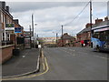
Edward Street (B6313) in Craghead
Looking north-westward.
Image: © Peter Wood
Taken: 31 Mar 2017
0.15 miles