IMAGES TAKEN NEAR TO
Money Hills, STANLEY, DH9 0RY
Introduction
This page details the photographs taken nearby to Money Hills, DH9 0RY by members of the Geograph project.
The Geograph project started in 2005 with the aim of publishing, organising and preserving representative images for every square kilometre of Great Britain, Ireland and the Isle of Man.

There are currently over 7.5m images from over14,400 individuals and you can help contribute to the project by visiting https://www.geograph.org.uk
Image Map
Images are licensed for reuse under creativecommons.org/licenses/by-sa/2.0
Notes
- Clicking on the map will re-center to the selected point.
- The higher the marker number, the further away the image location is from the centre of the postcode.
Image Listing (8 Images Found)
Images are licensed for reuse under creativecommons.org/licenses/by-sa/2.0
Image
Details
Distance
1
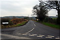
Cranberry Bog Road
The road junction at Pockerly Buildings (a rather grand name for a couple of houses) looking southwest along the wonderfully named road towards High Forge. Bog Hill is out of the picture on the left.
Image: © Alan Fearon
Taken: 6 Feb 2006
0.12 miles
2
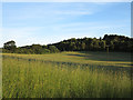
Field with long grass
The field is close to the County Durham village of Beamish and to a feature named on OS maps as Money Hills. An electricity transmission line crosses the field held on wooden poles.
Image: © Trevor Littlewood
Taken: 9 Jul 2014
0.13 miles
3

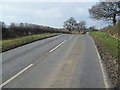
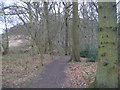
Footpath through Ousbrough Wood on Ousbrough Hill near to Beamish
Looking southward.
Image: © Peter Wood
Taken: 16 Feb 2019
0.18 miles
5
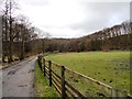
Track along to Mount Escob
View of the woods west of Urpeth Forge.
Image: © Robert Graham
Taken: 6 Feb 2013
0.21 miles
7
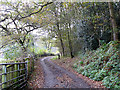
Bridleway to Ousborough Wood
This well-maintained path along the valley of the Beamish Burn has been signed as a cycle route.
Image: © Oliver Dixon
Taken: 31 Oct 2014
0.24 miles
8
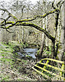
Collapsed river bank and so collapsed fence
The stream is the Beamish Burn and the location, close to the Beamish Open-air Museum.
Image: © Trevor Littlewood
Taken: 12 Mar 2023
0.25 miles