IMAGES TAKEN NEAR TO
Beamish, STANLEY, DH9 0RX
Introduction
This page details the photographs taken nearby to DH9 0RX by members of the Geograph project.
The Geograph project started in 2005 with the aim of publishing, organising and preserving representative images for every square kilometre of Great Britain, Ireland and the Isle of Man.

There are currently over 7.5m images from over14,400 individuals and you can help contribute to the project by visiting https://www.geograph.org.uk
Image Map
Images are licensed for reuse under creativecommons.org/licenses/by-sa/2.0
Notes
- Clicking on the map will re-center to the selected point.
- The higher the marker number, the further away the image location is from the centre of the postcode.
Image Listing (32 Images Found)
Images are licensed for reuse under creativecommons.org/licenses/by-sa/2.0
Image
Details
Distance
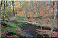
1

Footpath through Ousbrough Wood on Ousbrough Hill near to Beamish
Looking southward.
Image: © Peter Wood
Taken: 16 Feb 2019
0.04 miles
2
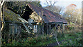
High Forge
"A number of interesting industrial sites survive along the Beamish Burn (most of which are in County Durham). High Forge is the most well preserved of all the buildings. It was originally a corn mill but was converted into a Trip Hammer Forge where bar iron was used for cannon making, shovels and files. First recorded in 1714 as Pigg Mill. Little survives of Middle Forge, although its location and the mill race can still be deduced. It was probably partially destroyed in the Beamish Burn flood in 1877. By 1895 buildings were still present but no races. In 1939 the buildings were demolished. The pumping station was built to work in conjunction with the drift mining in the area to remove the water from the mine shafts. Two shafts were present by the engine house. There are records of an "old engine" in 1836, but by 1839 the water wheel power became insufficient to remove water so a steam engine was erected in 1860 and closed c.1926. Low Forge, known as "Hussey's Forge" in 1764, is probably the oldest of the three forges. It closed in 1877 due to the Beamish Burn flood and the buildings were demolished in 1895. The well-covered remains of a stone archway still exist as the entrance to the Paper Mill or Money Hill drift, in operation from 1895 to 1920. One of the buildings of Urpeth Paper Mill still stands and is used as a stable. Mount Escop was originally worker's cottages. The mill was in use from at least 1792 and may have been destroyed by the flood in 1877. Few records exist of wagonways but they were present in the burn between 1895-1903. The forges were a significant contributor to armaments (canon making) around 1800, especially for the Napoleonic Wars. High and Low Quarries probably supplied stone for the Beamish Estate. High Quarry provided high quality stone, and Low Quarry provided stone for less important buildings. Since c.1900 they have been used for dumping rubbish so little remains. John Eden's Almshouses were built in 1836 by John Eden, landowner of Beamish, as retirement homes for workers from his estate."
Taken from sitelines.newcastle.gov.uk. (2021). Beamish Burn, industrial archaeological remains. [online] Available at: https://twsitelines.info/SMR/1027 [Accessed 2 Dec. 2021].
Image: © Mick Garratt
Taken: 21 Nov 2021
0.05 miles
3

High Forge near Beamish
View of the cottages from the path leading up from Ousbrough Wood.
Image: © Robert Graham
Taken: 6 Feb 2013
0.06 miles

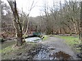
5
Collapsed river bank and so collapsed fence
The stream is the Beamish Burn and the location, close to the Beamish Open-air Museum.
Image: © Trevor Littlewood
Taken: 12 Mar 2023
0.11 miles
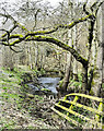
6
Footbridge in Ousbrough Wood
Footbridge over the Beamish Burn near High Forge.
Image: © Robert Graham
Taken: 6 Feb 2013
0.16 miles

8

Field with long grass
The field is close to the County Durham village of Beamish and to a feature named on OS maps as Money Hills. An electricity transmission line crosses the field held on wooden poles.
Image: © Trevor Littlewood
Taken: 9 Jul 2014
0.17 miles
9
Ruined stone wall
Probably the remains of the Low Forge, "known as 'Hussey's Forge' in 1764, is probably the oldest of the three forges. It closed in 1877 due to the Beamish Burn flood and the buildings were demolished in 1895."
sitelines.newcastle.gov.uk. (2021). Beamish Burn, industrial archaeological remains. [online] Available at: https://twsitelines.info/SMR/1027#:~:text=Low%20Forge%2C%20known%20as%20%22Hussey%27s%20Forge%22%20in%201764%2C%20is%20probably%20the%20oldest%20of%20the%20three%20forges.%20It%20closed%20in%201877%20due%20to%20the%20Beamish%20Burn%20flood%20and%20the%20buildings%20were%20demolished%20in%201895. [Accessed 2 Dec. 2021].
Image: © Mick Garratt
Taken: 21 Nov 2021
0.18 miles
10
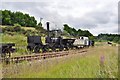
Puffing Billy
The replica locomotive seen steaming here on a train at Beamish.
Image: © Ashley Dace
Taken: 29 Jul 2011
0.22 miles