IMAGES TAKEN NEAR TO
Edmundbyers, CONSETT, DH8 9TX
Introduction
This page details the photographs taken nearby to DH8 9TX by members of the Geograph project.
The Geograph project started in 2005 with the aim of publishing, organising and preserving representative images for every square kilometre of Great Britain, Ireland and the Isle of Man.

There are currently over 7.5m images from over14,400 individuals and you can help contribute to the project by visiting https://www.geograph.org.uk
Image Map
Images are licensed for reuse under creativecommons.org/licenses/by-sa/2.0
Notes
- Clicking on the map will re-center to the selected point.
- The higher the marker number, the further away the image location is from the centre of the postcode.
Image Listing (24 Images Found)
Images are licensed for reuse under creativecommons.org/licenses/by-sa/2.0
Image
Details
Distance
1
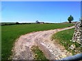
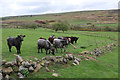
Limerick Cottage
Limerick Cottage above Burnhope Bridge.
Image: © Peter McDermott
Taken: 11 Jul 2010
0.02 miles
2
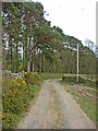
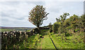
Limerick Cottage, Edmundbyers
Looking up the track to the farm and the moors behind.
Image: © Robert Graham
Taken: 20 Apr 2011
0.03 miles
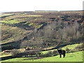
4
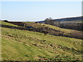
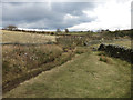
Grassed lane west of Burnhope Bridge
This is south-west of the village of Edmundbyers heading towards Limerick Edge. Burnhope Burn is out of view, below the wall to the left.
Image: © Trevor Littlewood
Taken: 10 Sep 2020
0.11 miles
8
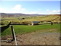
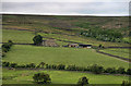
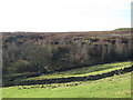
Barn at Edmundbyers
This barn lies to the west of the village, on the edge of the moors. It appears new or perhaps renovated in contrast to the majority of field barns in the uplands, and is obviously for the use of the horses. Beyond can be seen the farms of, firstly, Limerick Cottage, and secondly, Harehope Hall.
Image: © Robert Graham
Taken: 1 May 2013
0.15 miles