IMAGES TAKEN NEAR TO
Blanchland, CONSETT, DH8 9PS
Introduction
This page details the photographs taken nearby to DH8 9PS by members of the Geograph project.
The Geograph project started in 2005 with the aim of publishing, organising and preserving representative images for every square kilometre of Great Britain, Ireland and the Isle of Man.

There are currently over 7.5m images from over14,400 individuals and you can help contribute to the project by visiting https://www.geograph.org.uk
Image Map
Images are licensed for reuse under creativecommons.org/licenses/by-sa/2.0
Notes
- Clicking on the map will re-center to the selected point.
- The higher the marker number, the further away the image location is from the centre of the postcode.
Image Listing (13 Images Found)
Images are licensed for reuse under creativecommons.org/licenses/by-sa/2.0
Image
Details
Distance
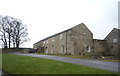
2
Farmhouse at Cowbyers
This stands on the B6306 North of Blanchland. Some very nice old buildings on this farm. The Derwent Reservoir can be seen to the right.
Image: © Robert Graham
Taken: 27 Sep 2011
0.02 miles
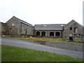
4
Converted farm buildings at Cowbyers
This traditional farm stands on the B6306 North of Blanchland. These buildings have been converted into modern apartments probably from an old barn.
Image: © Robert Graham
Taken: 27 Sep 2011
0.02 miles
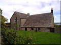
5
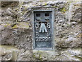
Ordnance Survey Flush Bracket G2996
This bracket can be found on one of the walls of a building at Cowbyers. The benchmark height is recorded as being 314.519 metres above sea level.
For more detail see : http://www.bench-marks.org.uk/bm11082
Image: © Peter Wood
Taken: 29 Mar 2017
0.03 miles
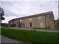
6
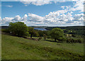
Fields east of Cowbyers
Cowbyers is a farm beside the B6306 north-east of Blanchland; the image records the view from that road, south of the farm. In the distance lies Derwent Reservoir.
Image: © Trevor Littlewood
Taken: 24 Jun 2011
0.10 miles
7
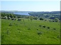
Hillside below Cowbyre Farm
The Derwent Reservoir Image in the distance
Image: © Oliver Dixon
Taken: 31 May 2020
0.12 miles
8
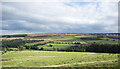
Field on east side of B6306
The field descends towards the River Derwent south-west of the Derwent Reservoir.
The ground beyond the valley rises to the moorland of Bainbridge Hill and Ruffside Moor.
Image: © Trevor Littlewood
Taken: 26 Sep 2021
0.13 miles
9
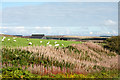
Rosebay willowherb gone to seed
The willowherb is in the shallow groove of a stream - Paddock Sike, and was photographed from the B6306 north of the buildings at Cowbyers.
Image: © Trevor Littlewood
Taken: 14 Oct 2015
0.14 miles
10
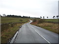
Park Bank (B6306)
Heading south west towards Blanchland.
Image: © JThomas
Taken: 2 Apr 2016
0.17 miles