IMAGES TAKEN NEAR TO
Blanchland, CONSETT, DH8 9PR
Introduction
This page details the photographs taken nearby to DH8 9PR by members of the Geograph project.
The Geograph project started in 2005 with the aim of publishing, organising and preserving representative images for every square kilometre of Great Britain, Ireland and the Isle of Man.

There are currently over 7.5m images from over14,400 individuals and you can help contribute to the project by visiting https://www.geograph.org.uk
Image Map
Images are licensed for reuse under creativecommons.org/licenses/by-sa/2.0
Notes
- Clicking on the map will re-center to the selected point.
- The higher the marker number, the further away the image location is from the centre of the postcode.
Image Listing (11 Images Found)
Images are licensed for reuse under creativecommons.org/licenses/by-sa/2.0
Image
Details
Distance
1
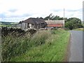
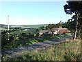
Balehill House Farm
Complete with a distinctly rickety looking barn.
Image: © Oliver Dixon
Taken: 2 Aug 2008
0.02 miles
2
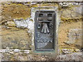
Ordnance Survey Flush Bracket G2999
This bracket can be found on the roadside wall of a building at Balehill. The benchmark height is recorded as being 334.451 metres above sea level.
For more detail see : http://www.bench-marks.org.uk/bm2540
Image: © Peter Wood
Taken: 29 Mar 2017
0.02 miles
3
Balehill House
View of Balehill House near Blanchland.
Image: © Peter McDermott
Taken: 26 Aug 2007
0.03 miles
4
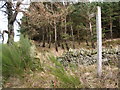
Footpath along the side of Balehill Plantation
Image: © Clive Nicholson
Taken: 23 Nov 2009
0.09 miles
5
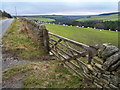
Grazing pasture at Balehill
Also showing the road up to Edmondbyers common and Deborah Plantation that surrounds Bolt's Burn in the valley bottom.
Image: © Clive Nicholson
Taken: 23 Nov 2009
0.14 miles
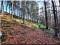
6
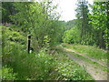
Boltsburn Plantation
Footpath through Boltsburn Plantation leading into Deborah Plantation
Image: © Les Hull
Taken: 7 Jun 2006
0.17 miles
7
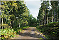
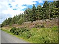
Forest road in Deborah Plantation
Deborah Plantation exists as ribbons of trees on both the east and west sides of Bolt's Burn; this road is on the east side and the view here is to the north.
Image: © Trevor Littlewood
Taken: 23 Sep 2019
0.17 miles
8
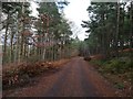
Forestry track in Boltsburn Plantation
Image: © Clive Nicholson
Taken: 22 Dec 2018
0.20 miles