IMAGES TAKEN NEAR TO
Edmundbyers, CONSETT, DH8 9NJ
Introduction
This page details the photographs taken nearby to DH8 9NJ by members of the Geograph project.
The Geograph project started in 2005 with the aim of publishing, organising and preserving representative images for every square kilometre of Great Britain, Ireland and the Isle of Man.

There are currently over 7.5m images from over14,400 individuals and you can help contribute to the project by visiting https://www.geograph.org.uk
Image Map
Images are licensed for reuse under creativecommons.org/licenses/by-sa/2.0
Notes
- Clicking on the map will re-center to the selected point.
- The higher the marker number, the further away the image location is from the centre of the postcode.
Image Listing (131 Images Found)
Images are licensed for reuse under creativecommons.org/licenses/by-sa/2.0
Image
Details
Distance
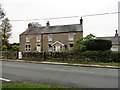
1
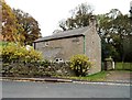
Edmunbyers House Cottage
This old cottage dates back to the 18th century. It was originally a byre, probably part of the farm at nearby Edmundbyers House. Stands beside the Stanhope road, the B6278.
Image: © Robert Graham
Taken: 21 Oct 2019
0.01 miles
2
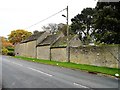
Former farm buildings along the B6278
These old byres stand alongside the Stanhope road, the B6278, on the south side of Edmundbyers village. Probably of 18th century date and part of the farm at Edmundbyers House nearby, they have been converted for residential use.
Image: © Robert Graham
Taken: 21 Oct 2019
0.01 miles
3
Edmondbyers and the valley of Burnhope Burn
Image: © Mike Quinn
Taken: 9 Jan 2013
0.01 miles
4
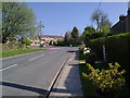
The Stanhope road leading out of Edmunbyers
Looking West along the B6278 back into the village
Image: © Robert Graham
Taken: 20 Apr 2011
0.02 miles
5
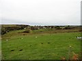
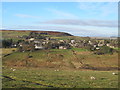
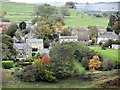
View of Edmundbyers from the south
Panoramic view of the village from the Muggleswick road.
Image: © Robert Graham
Taken: 21 Oct 2019
0.02 miles
6
Edmundbyers
View looking across Burnhope Burn towards Edmundbyers.
Image: © Peter McDermott
Taken: 11 Jul 2010
0.02 miles
7
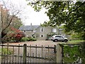
Edmundbyers House
A large private property on the south side of the village. This started out as a farmstead on the south side of the village green, probably in the early 18th century. There have been many additions and alterations since.
Image: © Robert Graham
Taken: 21 Oct 2019
0.02 miles
8
North View, Edmundbyers
This house is on the B6278 on the southern side of the village. It was originally a late 19th century farmhouse.
Image: © Robert Graham
Taken: 21 Oct 2019
0.03 miles
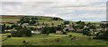
9
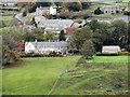
East side of Edmundbyers
Good views of the village are to be had from the Muggleswick road on the south slope of the valley to the south. Of particular interest here is the large detached house on the far left, with double wings. This is The Shooting Box, an early Victorian hunting lodge, constructed in vernacular style.
Image: © Robert Graham
Taken: 21 Oct 2019
0.03 miles
10
Edmundbyers House from the south
A view of the west side of Edmundbyers village from the Muggleswick road. Edmundbyers House is on the left front of the picture. It is a former 18th century farmhouse, much extended in later times and now a large private house.
Image: © Robert Graham
Taken: 21 Oct 2019
0.04 miles