IMAGES TAKEN NEAR TO
Knitsley Nook, CONSETT, DH8 9EE
Introduction
This page details the photographs taken nearby to Knitsley Nook, DH8 9EE by members of the Geograph project.
The Geograph project started in 2005 with the aim of publishing, organising and preserving representative images for every square kilometre of Great Britain, Ireland and the Isle of Man.

There are currently over 7.5m images from over14,400 individuals and you can help contribute to the project by visiting https://www.geograph.org.uk
Image Map
Images are licensed for reuse under creativecommons.org/licenses/by-sa/2.0
Notes
- Clicking on the map will re-center to the selected point.
- The higher the marker number, the further away the image location is from the centre of the postcode.
Image Listing (23 Images Found)
Images are licensed for reuse under creativecommons.org/licenses/by-sa/2.0
Image
Details
Distance
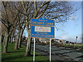
1
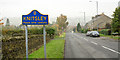
Knitsley
Knitsley is a hamlet on the outskirts of Consett. The road entering it is Butsfield Road beside which stands a blue and yellow sign in the typical County Durham style.
Image: © Trevor Littlewood
Taken: 4 Nov 2015
0.06 miles
2

Open Day at the Elddis factory in Consett
Bright new vans to tempt motorhomers and caravanners
Image: © Eirian Evans
Taken: 21 Sep 2019
0.06 miles
3
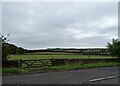
A view from Butsfield Lane
Looking over the countryside from the at Knitsley, with Humber Hill near Lanchester prominent on the horizon.
Image: © Robert Graham
Taken: 3 Oct 2022
0.10 miles
4
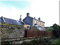
Former station house at Knitsley
This was a station on the Lanchester Valley Line and many of the stations were to a distinctive design by Thomas Prosser, an architect for the North Eastern Railway Company. The crowstep gables are noticeable. This station closed in 1964, and the whole line 2 years later.
Image: © Robert Graham
Taken: 11 Nov 2019
0.11 miles
5
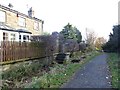
The station platform at Knitsley
This was a station on the Lanchester Valley Line, opened in 1862 and closed in 1964. The line is now the Lanchester Valley Railway Walk. The old station house is still here also.
Image: © Robert Graham
Taken: 11 Nov 2019
0.11 miles
6
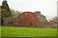
Corrugated metal barn at West Knitsley Grange
There's a typically varied collection of out-buildings at West Knitsley Grange.
Image: © Trevor Littlewood
Taken: 4 Nov 2015
0.17 miles
7
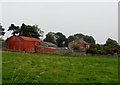
West Knitsley Grange
Viewed from Butsfield Lane, looking east. One of four farms in this grid square and all working ones too, which is most unusual these days.
Image: © Robert Graham
Taken: 21 Sep 2014
0.19 miles
8
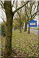
Trees alongside Delves Lane
Delves Lane beside the trees is seen passing through Delves which is a district of Consett.
The blue and yellow sign is in a style found frequently in County Durham. Often, as in this case, these signs have a little additional information about the place that's being entered.
Image: © Trevor Littlewood
Taken: 4 Nov 2015
0.19 miles
9
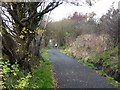
Lanchester Valley Railway Path
The Lanchester Valley Railway Path (part of National Cycle Network route 14) follows the line of the old railway from Durham to Lydgetts Junction. Popular with dog walkers.
Image: © Oliver Dixon
Taken: 13 Nov 2012
0.20 miles
10
Delves Lane road sign
Road sign, road and housing at south end of village
Image: © Vivienne Smith
Taken: 11 Jan 2006
0.20 miles