IMAGES TAKEN NEAR TO
Muggleswick, CONSETT, DH8 9DR
Introduction
This page details the photographs taken nearby to DH8 9DR by members of the Geograph project.
The Geograph project started in 2005 with the aim of publishing, organising and preserving representative images for every square kilometre of Great Britain, Ireland and the Isle of Man.

There are currently over 7.5m images from over14,400 individuals and you can help contribute to the project by visiting https://www.geograph.org.uk
Image Map
Images are licensed for reuse under creativecommons.org/licenses/by-sa/2.0
Notes
- Clicking on the map will re-center to the selected point.
- The higher the marker number, the further away the image location is from the centre of the postcode.
Image Listing (23 Images Found)
Images are licensed for reuse under creativecommons.org/licenses/by-sa/2.0
Image
Details
Distance
1
Across valley of Hisehope Burn
Hisehope Burn is a significant feeding stream to the River Derwent, itself a tributary of the River Tyne. The view is from a minor road beside a house called Fox Holes.
Image: © Trevor Littlewood
Taken: 20 Nov 2016
0.09 miles
2
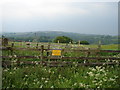
No Parking
Bit difficult to park never mind the signpost!
Image: © Ian Paterson
Taken: 3 Jun 2007
0.19 miles
3
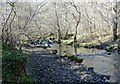
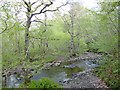
Looking along Horsleyhope Burn
The burn runs through the woods here at Comb Bridges, in Muggleswick Woods Nature Reserve.
Image: © Robert Graham
Taken: 14 Mar 2022
0.19 miles
4
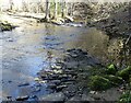
Remains of old road across the burn
There seems to be the remains of an old road surface on the nearside of the stream here at the ford over the Horsleyhope Burn.
Image: © Robert Graham
Taken: 14 Mar 2022
0.20 miles
5
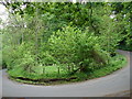
Hairpin or Roundabout?
If you think this is a sharp bend, keep travelling downhill.
Image: © Ian Paterson
Taken: 3 Jun 2007
0.20 miles
6
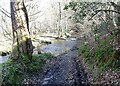
Ford over the Horsleyhope Burn
This is the site of an old ford near Comb Bridges. Seems to be still in use by farm traffic.
Image: © Robert Graham
Taken: 14 Mar 2022
0.21 miles
7
Ford over the Horsleyhope Burn
This little track, presumably used by forestry workers, leads over the burn just off the road near Coomb Bridges.
Image: © Robert Graham
Taken: 20 May 2015
0.21 miles
8
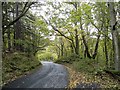
The road down to Comb Bridges
Looking east down the road from Muggleswick to Healeyfield. This is a very steep section going down into the bottom of the valley of the Hisehope Burn. The warning sign ahead is for a fearsome hairpin bend.
Image: © Robert Graham
Taken: 21 Oct 2019
0.22 miles
9
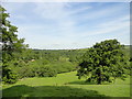
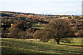
View over the field in front of Fox Holes
Looking west in front of the farm across the woods along the River Derwent. A really beautiful setting. The farm on the horizon in the middle of the picture is Crooked Oak, dating from the seventeenth century.
Image: © Robert Graham
Taken: 20 Jun 2012
0.22 miles
10
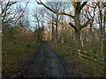
Track to Lead Mill
This carries the public footpath through the Derwent Gorge woodland.
Image: © Alan Murray-Rust
Taken: 28 Dec 2016
0.22 miles