IMAGES TAKEN NEAR TO
Muggleswick, CONSETT, DH8 9DL
Introduction
This page details the photographs taken nearby to DH8 9DL by members of the Geograph project.
The Geograph project started in 2005 with the aim of publishing, organising and preserving representative images for every square kilometre of Great Britain, Ireland and the Isle of Man.

There are currently over 7.5m images from over14,400 individuals and you can help contribute to the project by visiting https://www.geograph.org.uk
Image Map (Loading...)


Getting Data...Please wait
Leaflet Map data © OpenStreetMap
Images are licensed for reuse under creativecommons.org/licenses/by-sa/2.0
Notes
- Clicking on the map will re-center to the selected point.
- The higher the marker number, the further away the image location is from the centre of the postcode.
Image Listing (21 Images Found)
Images are licensed for reuse under creativecommons.org/licenses/by-sa/2.0
Image
Details
Distance
1
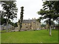
Haverley Lodge
This large house beside the Muggleswick to Healeyfield road was built in the mid C19 as the vicarage for Muggleswick church. It became a private house in the 1950's.
Image: © Robert Graham
Taken: 22 Aug 2017
0.01 miles
2
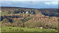
View of Haverley Lodge from the A68 at Castleside
View of this 19th century country house on the edge of the moors at Muggleswick in NZ0449from the road just north of Castleside village, NZ0749.
Image: © Robert Graham
Taken: 9 Jan 2023
0.01 miles
3
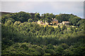
Key West
View looking across the valley of the River Derwent of the houses at Key West.
Image: © Peter McDermott
Taken: 11 Jul 2010
0.02 miles
4
View of Key West from the road
Large country house on the minor road East of Muggleswick.
Image: © Robert Graham
Taken: 20 Apr 2011
0.02 miles
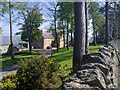
5
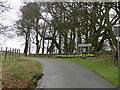
Road entering Muggleswick near Haverley Lodge
Looking north-westward.
Image: © Peter Wood
Taken: 29 Mar 2017
0.04 miles
6
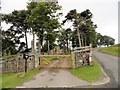
Entrance to Haverley Lodge
View looking east from the roadside of the lane from Muggleswick. The large house here was once the vicarage for Muggleswick church.
Image: © Robert Graham
Taken: 22 Aug 2017
0.04 miles
7
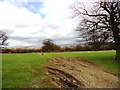
Ruined building in the field
North of the road leading south past Haverley Lodge, near Muggleswick. Possibly an old field barn.
Image: © Robert Graham
Taken: 1 May 2013
0.09 miles
8
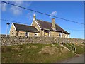
Muggleswick Parish Hall
A short way out of the village near Shield Farm. A small wind turbine stands at the rear.
Image: © Oliver Dixon
Taken: 1 Nov 2013
0.11 miles
9
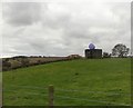
Pillbox with a smiley face
This is in a field just south of Muggleswick, near Shield Farm. I believe the smiley face is something to do with "likes" on Facebook. The pillbox must date back to WW2, and you don't see too many surviving ones these days.
Image: © Robert Graham
Taken: 21 Oct 2019
0.15 miles
10
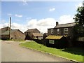
Shield Farm, Muggleswick
Farm beside the road leading south from Muggleswick village.
Image: © Robert Graham
Taken: 18 Jun 2014
0.16 miles