IMAGES TAKEN NEAR TO
Muggleswick, CONSETT, DH8 9DH
Introduction
This page details the photographs taken nearby to DH8 9DH by members of the Geograph project.
The Geograph project started in 2005 with the aim of publishing, organising and preserving representative images for every square kilometre of Great Britain, Ireland and the Isle of Man.

There are currently over 7.5m images from over14,400 individuals and you can help contribute to the project by visiting https://www.geograph.org.uk
Image Map
Images are licensed for reuse under creativecommons.org/licenses/by-sa/2.0
Notes
- Clicking on the map will re-center to the selected point.
- The higher the marker number, the further away the image location is from the centre of the postcode.
Image Listing (16 Images Found)
Images are licensed for reuse under creativecommons.org/licenses/by-sa/2.0
Image
Details
Distance
1
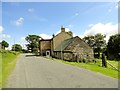
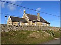
Dyke House
This old house stands by the roadside on a minor road south of Muggleswick. It appears to have been a farm at one time, but not now.
Image: © Robert Graham
Taken: 18 Jun 2014
0.01 miles
2
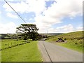
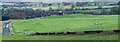
Road south of Muggleswick
Looking south along the country lane which leads to the Waskerley road. Open moorland to the right. Dyke House in the distance.
Image: © Robert Graham
Taken: 18 Jun 2014
0.03 miles
4
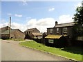
Shield Farm, Muggleswick
Farm beside the road leading south from Muggleswick village.
Image: © Robert Graham
Taken: 18 Jun 2014
0.12 miles
5
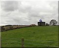
Pillbox with a smiley face
This is in a field just south of Muggleswick, near Shield Farm. I believe the smiley face is something to do with "likes" on Facebook. The pillbox must date back to WW2, and you don't see too many surviving ones these days.
Image: © Robert Graham
Taken: 21 Oct 2019
0.15 miles
6
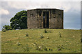
Shield Farm
Pillbox in field at Shield farm.
Image: © Peter McDermott
Taken: 11 Jul 2010
0.16 miles
7
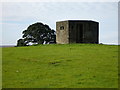
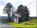
Pill Box
Pill Box below Muggleswick Park.
Would love to hear the history of this !
Image: © Clive Nicholson
Taken: 24 Sep 2005
0.16 miles
8
Pillbox at Shield Farm, Muggleswick
Standard Type 22 hexagonal type, not included in the Defence of Britain database.
Image: © Alan Murray-Rust
Taken: 28 Dec 2016
0.17 miles
9
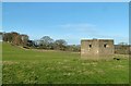
Pill box in field with sheep
The World War II feature is in a field close to Shield Farm. Curiously, there's a plastic-wrapped silage bale on its roof, lodged there no doubt for future use, but how tantalising for hungry sheep to see it, just out of reach!
Image: © Trevor Littlewood
Taken: 13 Dec 2019
0.18 miles
10
Muggleswick Parish Hall
A short way out of the village near Shield Farm. A small wind turbine stands at the rear.
Image: © Oliver Dixon
Taken: 1 Nov 2013
0.18 miles