IMAGES TAKEN NEAR TO
First Street, Pont Bungalows, CONSETT, DH8 6JE
Introduction
This page details the photographs taken nearby to First Street, Pont Bungalows, DH8 6JE by members of the Geograph project.
The Geograph project started in 2005 with the aim of publishing, organising and preserving representative images for every square kilometre of Great Britain, Ireland and the Isle of Man.

There are currently over 7.5m images from over14,400 individuals and you can help contribute to the project by visiting https://www.geograph.org.uk
Image Map
Images are licensed for reuse under creativecommons.org/licenses/by-sa/2.0
Notes
- Clicking on the map will re-center to the selected point.
- The higher the marker number, the further away the image location is from the centre of the postcode.
Image Listing (24 Images Found)
Images are licensed for reuse under creativecommons.org/licenses/by-sa/2.0
Image
Details
Distance
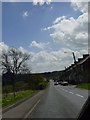
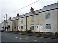
1
Top end of Pont Bungalows
These terraced cottages are at the north end of Leadgate village, beside the B6309. This is the old Roman road of Dere Street. These bungalows are ex miners cottages originally built by Consett Iron Company for the workers in its pits.
Image: © Robert Graham
Taken: 25 Nov 2020
0.01 miles
2
Watling Street, Pont
The B6309 to the north of the village of Leadgate. This road lies along the course of the ancient Dere Street.
Image: © Oliver Dixon
Taken: 2 Oct 2018
0.03 miles
3
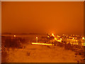
Leadgate on a snowy night
Taken New Years Day 2004
Image: © Geoff Gill
Taken: 1 Jan 2004
0.13 miles
4
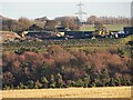
Looking over to the opencast site
This is a zoomed view from Corbridge Road in Leadgate looking over to Bradley opencast coal mine. This area beside the A692 in Image is used as the vehicle park.
Image: © Robert Graham
Taken: 25 Nov 2020
0.15 miles
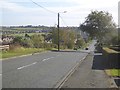
5
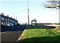
Hill top bus stop
This is on Corbridge Road at Leadgate. It's at the top of the bank going north from the village on the B6309, which follows the course of the Roman road of Dere Street. The shelter is over the road from Pleasant View.
Image: © Robert Graham
Taken: 25 Nov 2020
0.16 miles
6
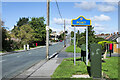
B6309 at Pont
Pont is a location in County Durham contiguous with Leadgate and presumably part of that same settlement. It has its own identity and its own County Durham road sign in the blue and yellow colours found in the county.
Image: © Trevor Littlewood
Taken: 15 Sep 2022
0.16 miles
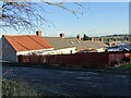
7
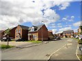
New estate at Pont Bungalows
These houses were built recently on the site of a former factory between the houses at Pont Bungalows and Bradley Bungalows in Leadgate.
Image: © Robert Graham
Taken: 9 Aug 2017
0.19 miles
8
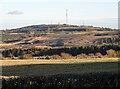
View of the opencast from the top of Corbridge Road
This is the view from the B6309, at the north end of Leadgate village. There is a great view of Pontop Pike from the bank top here, but the view is dominated by the Bradley opencast coal mine. Not a pretty sight.
Image: © Robert Graham
Taken: 25 Nov 2020
0.19 miles