IMAGES TAKEN NEAR TO
North Holm, CONSETT, DH8 6DX
Introduction
This page details the photographs taken nearby to North Holm, DH8 6DX by members of the Geograph project.
The Geograph project started in 2005 with the aim of publishing, organising and preserving representative images for every square kilometre of Great Britain, Ireland and the Isle of Man.

There are currently over 7.5m images from over14,400 individuals and you can help contribute to the project by visiting https://www.geograph.org.uk
Image Map
Images are licensed for reuse under creativecommons.org/licenses/by-sa/2.0
Notes
- Clicking on the map will re-center to the selected point.
- The higher the marker number, the further away the image location is from the centre of the postcode.
Image Listing (51 Images Found)
Images are licensed for reuse under creativecommons.org/licenses/by-sa/2.0
Image
Details
Distance
1

South Cross Street
Former miners' cottages.
Image: © Paul Franks
Taken: 12 May 2015
0.07 miles
2
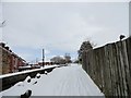
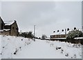
Railway path at Leadgate in the snow
This is now the Consett to Sunderland Railway Path, just behind Front Street in Leadgate village. Looking east here, near the former location of the station. The houses are in Railway Street, appropriately. Heavy snow here overnight in late February.
Image: © Robert Graham
Taken: 27 Feb 2018
0.07 miles
3
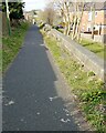
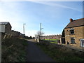
The old line at Leadgate
The former railway line just behind the main street in the village is now a footpath and cycle route. It forms part of the Consett and Sunderland Railway Path.
Image: © Robert Graham
Taken: 18 Mar 2021
0.08 miles
4
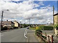
Watling Street, Leadgate
Looking north up this road through the village. It is the B6309 and here it follows the line of the old Roman road of Dere Street. Not Watling Street, despite the name.
Image: © Robert Graham
Taken: 9 Aug 2017
0.09 miles
5

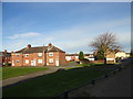
Square Behind South Cross Street
The Leadgate miners' cottages were built in squares in the 1840's. The original cottages had no toilets or running water, and the squares contained earth closets, one for every 3 cottages, and a communal pump or stand pipe. They were also used for drying washing, storing coal, dumping rubbish and keeping pigs.
Image: © Paul Franks
Taken: 12 May 2015
0.09 miles
6
Terraced streets in Leadgate
Old terraced housing behind the main street in the village. Tindale Street is the nearest. The picture eis taken from the former railway line.
Image: © Robert Graham
Taken: 2 Nov 2016
0.09 miles
7
Snowy footpath at Leadgate
Looking west along the Consett to Sunderland Railway Path, behind Front Street in the village.
Image: © Robert Graham
Taken: 27 Feb 2018
0.10 miles
8
The old railway in Leadgate
This is the C to C footpath which now runs along the former railway line just behind the village main street. The terraced streets here date from the C19.
Image: © Robert Graham
Taken: 2 Nov 2016
0.10 miles
9
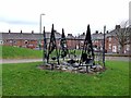
Public artwork at Leadgate
This example of public artwork has been recently erected on a small green on the site of a demolished house on Front Street, Leadgate. The Consett and Sunderland railway path (part of the famous C2C cycle route) runs on the far side of the green.
Image: © Oliver Dixon
Taken: 13 Nov 2012
0.11 miles
10
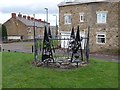
Public artwork, Leadgate
This example of public artwork has been recently erected on a small green on the site of a demolished house on Front Street, Leadgate. The Consett and Sunderland railway path (part of the famous C2C cycle route) runs on the far side of the green.
Image: © Oliver Dixon
Taken: 13 Nov 2012
0.11 miles