IMAGES TAKEN NEAR TO
Balmoral Grove, CONSETT, DH8 6DE
Introduction
This page details the photographs taken nearby to Balmoral Grove, DH8 6DE by members of the Geograph project.
The Geograph project started in 2005 with the aim of publishing, organising and preserving representative images for every square kilometre of Great Britain, Ireland and the Isle of Man.

There are currently over 7.5m images from over14,400 individuals and you can help contribute to the project by visiting https://www.geograph.org.uk
Image Map
Images are licensed for reuse under creativecommons.org/licenses/by-sa/2.0
Notes
- Clicking on the map will re-center to the selected point.
- The higher the marker number, the further away the image location is from the centre of the postcode.
Image Listing (44 Images Found)
Images are licensed for reuse under creativecommons.org/licenses/by-sa/2.0
Image
Details
Distance
1
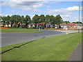
Housing development, Balmoral Grove
Formerly, allotments. A few allotments still exist to the east of the development. Viewed across Number One roundabout.
Image: © Pauline E
Taken: 25 Jul 2009
0.02 miles
2
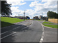
Approach to Number One roundabout
Along Villa Real Road, A691.
Image: © Pauline E
Taken: 25 Jul 2009
0.04 miles
3
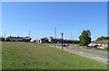
Approach to No 1 roundabout from the east
View along Villa Real Road at Consett to the roundabout on Medomsley Road. The strange name comes from The No 1 Pit, established nearby in the 1840's by the Derwent Iron Company to mine both coal and iron ore. This was the forerunner of the Consett Iron Company of later times.
Image: © Robert Graham
Taken: 31 May 2020
0.04 miles
4
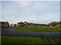
No 1 roundabout, Consett
This district on the north side of Consett takes its name from the No1 Pit. This was the first pit in the area and mined both coal and ironstone for the new iron works at Consett in the 1840's.
Image: © Robert Graham
Taken: 30 Nov 2016
0.06 miles
5
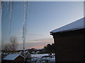
Wintry view to Balmoral Grove, Consett
Looking across Villa Real Road with a few inches of snow with more to come later in the day.
Image: © Pauline E
Taken: 20 Dec 2009
0.07 miles
6
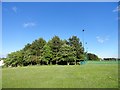
Copse beside Consett Rugby Club
This strip of trees stands between the A691 road and the playing fields, on the north side of Consett.
Image: © Robert Graham
Taken: 3 Jun 2017
0.07 miles
7
Consett Number One Club
Number One is the name of the area. The club is the tallest building in the row.
Image: © Pauline E
Taken: 25 Jul 2009
0.08 miles
8
Phonebox by Number 1 roundabout, Medomsley Rd.
Taken on a dull day in December.
Image: © Pauline E
Taken: 28 Dec 2007
0.08 miles
9
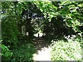
Old path through the trees
This path is on a bit of waste land in the middle of No 1 Industrial Estate. It is shown on old maps as a path to Bunker Hill Farm. The stone gate post at the end here has probably been moved into the middle to deter unauthorized vehicles.
Image: © Robert Graham
Taken: 31 May 2020
0.09 miles
10
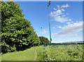
Path alongside the playing fields
These are the playing fields of Consett Rugby Club, behind the metal fence. There are two large floodlight pylons here also. The little path is a favourite of local dog walkers.
Image: © Robert Graham
Taken: 3 Jun 2017
0.09 miles