IMAGES TAKEN NEAR TO
Riverside Industrial Estate, DURHAM, DH7 9TT
Introduction
This page details the photographs taken nearby to Riverside Industrial Estate, DH7 9TT by members of the Geograph project.
The Geograph project started in 2005 with the aim of publishing, organising and preserving representative images for every square kilometre of Great Britain, Ireland and the Isle of Man.

There are currently over 7.5m images from over14,400 individuals and you can help contribute to the project by visiting https://www.geograph.org.uk
Image Map
Images are licensed for reuse under creativecommons.org/licenses/by-sa/2.0
Notes
- Clicking on the map will re-center to the selected point.
- The higher the marker number, the further away the image location is from the centre of the postcode.
Image Listing (32 Images Found)
Images are licensed for reuse under creativecommons.org/licenses/by-sa/2.0
Image
Details
Distance
1
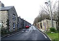
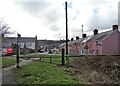
View along Railway Street, Langley Park
This is one of the earliest built terraces in this former mining village. It dates from the last quarter of the 19th century. It is in relatively original appearance too, which has led to it being used on several occasions as a film set. Of particular note are the outhouses opposite, which would have housed coalhouse and dry toilet originally.
Image: © Robert Graham
Taken: 21 Feb 2022
0.06 miles
2

Entrance to Diggerland at Langley Park
Image: © Peter Robinson
Taken: 12 May 2013
0.06 miles
3
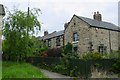
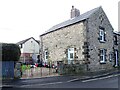
Railway Street, Langley Park
A much improved street in the ex-mining village of Langley Park.
Image: © Ann Hodgson
Taken: 28 May 2003
0.06 miles
4
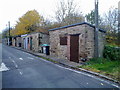
Old privies at Langley Park
These are at Railway Street, across the road from the houses. I assume they once contained the dry toilets or were possibly coal houses.
Image: © Robert Graham
Taken: 2 Nov 2011
0.07 miles
5
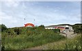
Diggerland Adventure Park
Diggerland at Langley Park.
Image: © Chris Thomas-Atkin
Taken: 23 Jun 2018
0.08 miles
6
Old terraced Streets at Langley Park
Some of the original Victorian terraces from the late 19th century founding of the mining village. The one on the right is Dale Street. Pictured from the Lanchester Valley Railway Walk, which runs along the north side of the village.
Image: © Robert Graham
Taken: 21 Feb 2022
0.08 miles
7
Top end of Railway Street
This is a late 19th century terrace in the ex-mining village of Langley Park. This end house is athwart the other houses and may have been a larger officials house originally, but that's only a guess.
Image: © Robert Graham
Taken: 21 Feb 2022
0.09 miles
8
Diggerland: Excavator and dumper truck area
Image: © Roger Smith
Taken: 15 Aug 2007
0.10 miles
9
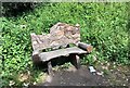
Decorative Seat
A decorative wooden seat beside the Lanchester Valley Railway Path.
Image: © Chris Thomas-Atkin
Taken: 23 Jun 2018
0.10 miles
10

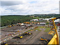
Roadways at 'Diggerland'
'Diggerland'lies on the north side of the Lanchester Valley Walk at Langley Park - for those who would like to drive, (or just see), large, (and small), yellow earth-moving equipment!
(Currently - January 2014 - an 'Individual JCB 90 minute experience', costs £149.99... but there are much cheaper options too.)
Image: © Trevor Littlewood
Taken: 11 Jan 2014
0.13 miles