IMAGES TAKEN NEAR TO
Roman Road, DURHAM, DH7 8UF
Introduction
This page details the photographs taken nearby to Roman Road, DH7 8UF by members of the Geograph project.
The Geograph project started in 2005 with the aim of publishing, organising and preserving representative images for every square kilometre of Great Britain, Ireland and the Isle of Man.

There are currently over 7.5m images from over14,400 individuals and you can help contribute to the project by visiting https://www.geograph.org.uk
Image Map
Images are licensed for reuse under creativecommons.org/licenses/by-sa/2.0
Notes
- Clicking on the map will re-center to the selected point.
- The higher the marker number, the further away the image location is from the centre of the postcode.
Image Listing (11 Images Found)
Images are licensed for reuse under creativecommons.org/licenses/by-sa/2.0
Image
Details
Distance
1
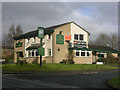
The Brawn's Den public house, Winchester Drive, Brandon
A very modern pub, named after the local belief that Brandon takes its name from Brawn's Den, or den of a notorious wild boar, a local semi-mythical beast, akin to the Lambton Worm (and that the nearby village of Brancepeth is likewise named after said beast). There is indeed, a farmstead nearby called Brawn's Den, but research suggests that the name Brandon has a quite different derivation.
Image: © Oliver Dixon
Taken: 17 Feb 2006
0.11 miles
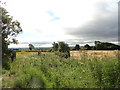
3
Brandon to Bishop Auckland Walk
At this point, the railway walk crosses the lane at the SE corner of Brandon village.
Image: © Robert Graham
Taken: 24 Jul 2012
0.14 miles
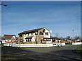
4
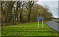
Roadside verge near Brandon
The road is entering Brandon at its southern point; the yellow and blue road sign is in a style in use in County Durham for some years.
Image: © Trevor Littlewood
Taken: 30 Nov 2014
0.14 miles
5
Footpath to the A690 from the Brandon - Bishop Auckland Railway Path
Image: © Peter Robinson
Taken: 11 Mar 2012
0.18 miles
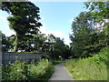
6
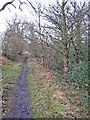
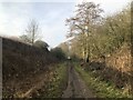
Scripton Gill, Brandon
This pleasant path runs along a narrow strip of woodland beside the stream from Brandon up to Pithouse Plantation.
Image: © Oliver Dixon
Taken: 23 Feb 2007
0.18 miles
7
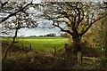
Field on north side of Brandon - Bishop Auckland Railway Path
The location is at the southern tip of the village of Brandon where, adjacent to Scripton Gill, a footpath heads north away from the railway route; it passes on the right side of the tree.
Image: © Trevor Littlewood
Taken: 30 Nov 2014
0.19 miles
8
View south from the old railway
This is now the Brandon - Bishop Auckland Walk, which here runs along the southern side of Brandon village.
Image: © Robert Graham
Taken: 24 Jul 2012
0.22 miles
9
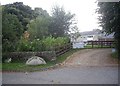
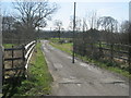
Access to Scripton Farm
Now redeveloped into seven separate dwellings, close to the A690 at Brancepeth.
Image: © Stanley Howe
Taken: 21 Sep 2013
0.23 miles
10
Route of the former Bishop Auckland - Durham railway at Brandon
Image: © David Robinson
Taken: 15 Feb 2023
0.24 miles