IMAGES TAKEN NEAR TO
Deerness Court, Station Avenue, DURHAM, DH7 8QZ
Introduction
This page details the photographs taken nearby to Deerness Court, Station Avenue, DH7 8QZ by members of the Geograph project.
The Geograph project started in 2005 with the aim of publishing, organising and preserving representative images for every square kilometre of Great Britain, Ireland and the Isle of Man.

There are currently over 7.5m images from over14,400 individuals and you can help contribute to the project by visiting https://www.geograph.org.uk
Image Map
Images are licensed for reuse under creativecommons.org/licenses/by-sa/2.0
Notes
- Clicking on the map will re-center to the selected point.
- The higher the marker number, the further away the image location is from the centre of the postcode.
Image Listing (6 Images Found)
Images are licensed for reuse under creativecommons.org/licenses/by-sa/2.0
Image
Details
Distance
1
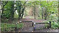
Brandon to Bishop Auckland Railway Path
This is part of National Cycle Network route 70.
Image: © Clive Nicholson
Taken: 21 Oct 2022
0.07 miles
2
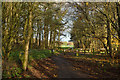
Brandon - Bishop Auckland Railway Path
The Brandon to Bishop Auckland Railway Path here is passing between Brandon and Meadowfield, heading north-east.
Image: © Trevor Littlewood
Taken: 30 Nov 2014
0.09 miles
3
Brandon Convenience Stone
On Brandon Lane.
Image: © Mick Garratt
Taken: 1 Feb 2014
0.18 miles
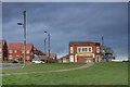
4
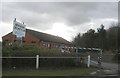
Brandon and Meadowfield Royal British Legion Club
On Chalfont way.
Image: © Mick Garratt
Taken: 1 Feb 2014
0.23 miles
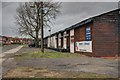
6
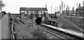
Brandon Colliery Station (remains)
View NE, towards Durham; ex-NER Bishop Auckland - Durham line. The station looks rather decrepit in 1965; it was closed to passengers on 4/5/64, to goods on 10/8/64; the line closed finally on 5/8/68.
Image: © Ben Brooksbank
Taken: 10 May 1965
0.25 miles