IMAGES TAKEN NEAR TO
Gerards Gill, DURHAM, DH7 8LH
Introduction
This page details the photographs taken nearby to Gerards Gill, DH7 8LH by members of the Geograph project.
The Geograph project started in 2005 with the aim of publishing, organising and preserving representative images for every square kilometre of Great Britain, Ireland and the Isle of Man.

There are currently over 7.5m images from over14,400 individuals and you can help contribute to the project by visiting https://www.geograph.org.uk
Image Map
Images are licensed for reuse under creativecommons.org/licenses/by-sa/2.0
Notes
- Clicking on the map will re-center to the selected point.
- The higher the marker number, the further away the image location is from the centre of the postcode.
Image Listing (9 Images Found)
Images are licensed for reuse under creativecommons.org/licenses/by-sa/2.0
Image
Details
Distance
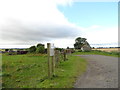
1
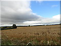
View to the west from Browney Lane
Looking across a large field of Barley, from the lane running south from Meadowfield towards Croxdale.
Image: © Robert Graham
Taken: 24 Jul 2012
0.02 miles
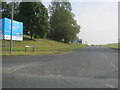
2
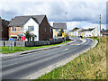
Detached house beside Browney Lane
The road is Browney Lane, the B6300. The detached house is one of a number of recently built properties just outside the village of Meadowfield. At the left side of the image is a road sign in the blue and yellow colours found typically in County Durham.
Image: © Trevor Littlewood
Taken: 16 Aug 2021
0.12 miles
3
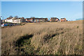
'Waste ground' south of Meadowfield
The waste ground lies between the B6300 and Meadowfield's West Business Park.
Image: © Trevor Littlewood
Taken: 25 Nov 2015
0.14 miles
4
Entering Browney from the south east
Image: © Peter Robinson
Taken: 23 Sep 2012
0.15 miles
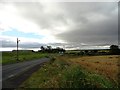
5
Smallholding near Meadowfield
Just off Browney Lane, south of the village.
Image: © Robert Graham
Taken: 24 Jul 2012
0.15 miles
6
St John's Road entrance to Meadowfield Industrial Estate
Image: © Peter Robinson
Taken: 23 Sep 2012
0.15 miles
7
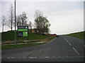
Road leading to Meadowfield Industrial Estate
New signs at the Meadowfield Industrial Estate.
Image: © Les Hull
Taken: 30 Apr 2006
0.16 miles
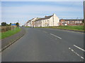
8
Looking south along Browney Lane
Just south of Meadowfield, Brandon. Ash Tree Farm just down the road.
Image: © Robert Graham
Taken: 24 Jul 2012
0.20 miles
9
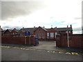
Browney Primary School, Meadowfield
Old school at Meadowfield, Brandon. Looks Edwardian possibly.
Image: © Robert Graham
Taken: 24 Jul 2012
0.20 miles