IMAGES TAKEN NEAR TO
Anns Place, DURHAM, DH7 8JY
Introduction
This page details the photographs taken nearby to Anns Place, DH7 8JY by members of the Geograph project.
The Geograph project started in 2005 with the aim of publishing, organising and preserving representative images for every square kilometre of Great Britain, Ireland and the Isle of Man.

There are currently over 7.5m images from over14,400 individuals and you can help contribute to the project by visiting https://www.geograph.org.uk
Image Map
Images are licensed for reuse under creativecommons.org/licenses/by-sa/2.0
Notes
- Clicking on the map will re-center to the selected point.
- The higher the marker number, the further away the image location is from the centre of the postcode.
Image Listing (17 Images Found)
Images are licensed for reuse under creativecommons.org/licenses/by-sa/2.0
Image
Details
Distance
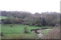
1
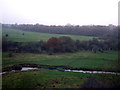
Railway viaduct over River Deerness
The viaduct carries the East Coast Main Line over the River Deerness close to its confluence with the River Browney.
Image: © Trevor Littlewood
Taken: 30 Nov 2014
0.04 miles
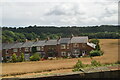
6
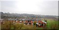
Farewell View, Langley Moor
A terrace of houses on the edge of the village, near the railway line.
Image: © Stephen Craven
Taken: 4 Aug 2017
0.14 miles
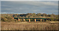
7
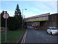
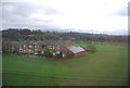
Railway bridge over the A690, Langley Moor
Carries the East Coast Main Line.
Image: © JThomas
Taken: 6 Dec 2015
0.14 miles
8
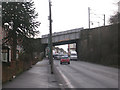
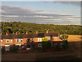
A690 at Langley Moor
The bridge carries the East Coast main line over the main Durham to Willington road
Image: © Oliver Dixon
Taken: 17 Feb 2006
0.14 miles