IMAGES TAKEN NEAR TO
Chadwick Close, DURHAM, DH7 7RH
Introduction
This page details the photographs taken nearby to Chadwick Close, DH7 7RH by members of the Geograph project.
The Geograph project started in 2005 with the aim of publishing, organising and preserving representative images for every square kilometre of Great Britain, Ireland and the Isle of Man.

There are currently over 7.5m images from over14,400 individuals and you can help contribute to the project by visiting https://www.geograph.org.uk
Image Map
Images are licensed for reuse under creativecommons.org/licenses/by-sa/2.0
Notes
- Clicking on the map will re-center to the selected point.
- The higher the marker number, the further away the image location is from the centre of the postcode.
Image Listing (20 Images Found)
Images are licensed for reuse under creativecommons.org/licenses/by-sa/2.0
Image
Details
Distance
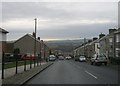
2
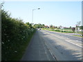
Whitehouse Lane, Ushaw Moor
Looking north east.
Image: © JThomas
Taken: 4 Jun 2016
0.10 miles
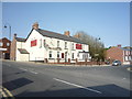
3
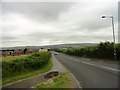
Looking down Whitehouse Lane, Bearpark
This lane at the west end of the village leads down to Ushaw Moor. As Bearpark is on the top of the ridge above the Deerness valley, there are good views from here.
Image: © Robert Graham
Taken: 10 Jul 2013
0.13 miles
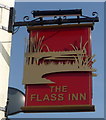
6
The Flass, Ushaw Moor
Pub in the centre of the village, which takes its name from the ancient manor of Flass Hall nearby.
Image: © Robert Graham
Taken: 10 Jul 2013
0.17 miles
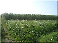
8
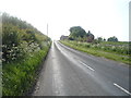
Woodland Road
Looking west near Red House Farm.
Image: © JThomas
Taken: 4 Jun 2016
0.19 miles
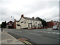
9
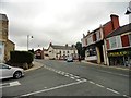
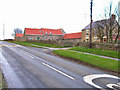
The village centre of Ushaw Moor
This is the junction of Cockhouse Lane with Durham Road in the centre of the village. Whitehouse Lane leads north up the middle of the picture. Ushaw Moor was founded in the mid 19th century as a colliery village. The pit closed in 1960. The village has survived better than most in the area, and still has a pub and plenty of shops.
Image: © Robert Graham
Taken: 10 Jul 2013
0.19 miles