IMAGES TAKEN NEAR TO
Black House Lane, DURHAM, DH7 6FG
Introduction
This page details the photographs taken nearby to Black House Lane, DH7 6FG by members of the Geograph project.
The Geograph project started in 2005 with the aim of publishing, organising and preserving representative images for every square kilometre of Great Britain, Ireland and the Isle of Man.

There are currently over 7.5m images from over14,400 individuals and you can help contribute to the project by visiting https://www.geograph.org.uk
Image Map
Images are licensed for reuse under creativecommons.org/licenses/by-sa/2.0
Notes
- Clicking on the map will re-center to the selected point.
- The higher the marker number, the further away the image location is from the centre of the postcode.
Image Listing (6 Images Found)
Images are licensed for reuse under creativecommons.org/licenses/by-sa/2.0
Image
Details
Distance
1
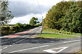
Road Junction: Black House Lane and Beechgrove Lane
Black House Lane, a road with 'B' classification, disappears at the centre of the image.
Image: © Trevor Littlewood
Taken: 26 Sep 2019
0.17 miles
2
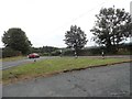
Road junction at bottom of Beechgrove Lane
Junction at the south end of Beechgrove Lane with Black House Lane.
Image: © Robert Graham
Taken: 9 Sep 2019
0.17 miles
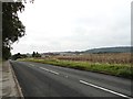
3
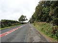
View along Black House Lane
Looking west along a long straight stretch of country road, just past the junction with Beechgrove Lane.
Image: © Robert Graham
Taken: 9 Sep 2019
0.20 miles
4
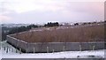
Edmondsley Reedbeds
Polluted minewater enters the Congburn stream. It is filtered by the reeds. The water is cleansed and returned to the stream. The reeds thrive on the pollutants.The reeds encourage wildlife.
Image: © Barry Wood
Taken: 3 Jan 2008
0.21 miles
5
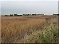
Edmondsley Reedbeds
Part of the Edmondsley Wildlife Habitat established in 1999. Contaminated mine water is filtered through the reedbeds before being returned to the Cong Burn.
Image: © Oliver Dixon
Taken: 31 Oct 2014
0.24 miles
6
Ghost village on Black House Lane
In the field on the right, a whole village of miners' houses once stood. Built before the war, they were declared a category D village in 1951, meaning the county council had decided they were not needed any more. Even though the category D was lifted in the 1970s, the village was eventually demolished in 1978. Just a couple of houses remain, as can be seen. I believe one of them was once the Working Men's Club.
Image: © Robert Graham
Taken: 9 Sep 2019
0.25 miles